1940s Maps of St. Francis, Kansas
Explore 2 historic maps of St. Francis from the 1940s. These maps offer a rare glimpse into what life looked like during the 1940s — showing old roads, neighborhoods, homes, and landmarks that have changed or disappeared over time.
Whether you're researching your family's past, planning a metal detecting trip, or studying how St. Francis's landscape evolved across the 1940s, these high-resolution maps are a powerful tool for exploring the history of this region.
- Focus on a specific era: All maps on this page are from the 1940s, giving you a focused view of this time period.
- See what’s changed: Compare century-old streets, trails, and buildings to today's modern landscape using overlays and satellite layers.
- Research with precision: Use these maps for genealogy, historical research, land use analysis, or educational projects.
- View, download, or print: Maps are fully viewable online in high resolution, and can be downloaded or printed for your own records.
Start exploring St. Francis's history through authentic maps from the 1940s. This is your window into the past.
St. Francis, KS maps
(2)- 1942 Map of St. Francis, 1943 Print
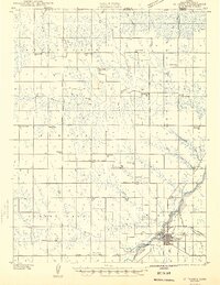 1942 St. Francis1943 Print · USGSCheyenne County and the Nebraska-Kansas border appear in the early 1940s as a landscape of rural schools and river-fed agriculture. Genealogists can locate family landmarks such as German Plains Sch, St Francis Cem, and the Zion Ch.
 - 1943 Map of St. Francis, 1949 Print
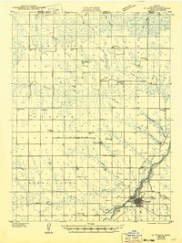 1943 St. Francis1949 Print · USGSWestern Kansas prairie life is captured here during the 1940s, centered on the river valley and rail lines of Cheyenne County. Trace the locations of rural schoolhouses and churches like German Plains Sch, Zion Ch, and the St Francis townsite.
End of results
Showing maps 1-2 of 2
Top cities near St. Francis
Top neighborhoods of St. Francis
Frequently asked questions
- What are the different types of historical maps available for St. Francis?
- What is the oldest map of St. Francis?
- Where can I purchase historical maps of St. Francis for my home or office?
- Where can I download high-res historical maps of St. Francis?
- Are there historical topographic maps available for St. Francis?
- Is there historical aerial imagery available for St. Francis?
- Where are historical maps of St. Francis sourced from?