1900s (20th Century) Maps of Clay Center, Kansas
Explore 8 historic maps of Clay Center from the 1900s (20th Century). These maps offer a rare glimpse into what life looked like during the 1900s — showing old roads, neighborhoods, homes, and landmarks that have changed or disappeared over time.
Whether you're researching your family's past, planning a metal detecting trip, or studying how Clay Center's landscape evolved across the 1900s, these high-resolution maps are a powerful tool for exploring the history of this region.
- Focus on a specific era: All maps on this page are from the 1900s, giving you a focused view of this time period.
- See what’s changed: Compare century-old streets, trails, and buildings to today's modern landscape using overlays and satellite layers.
- Research with precision: Use these maps for genealogy, historical research, land use analysis, or educational projects.
- View, download, or print: Maps are fully viewable online in high resolution, and can be downloaded or printed for your own records.
Start exploring Clay Center's history through authentic maps from the 1900s. This is your window into the past.
Clay Center, KS maps
(8)- 1955 Map of Manhattan, 1964 Print
 1955 Manhattan1964 Print · USGSNorth Central Kansas is captured here in the mid-fifties, just as major flood control projects began reshaping the river valleys. Genealogists can locate family sites near St. Joseph Church, Sunset Cemetery, or along the busy tracks of the Rock Island RR.4 unique versions available
 - 1956 Map of Manhattan
 1956 Manhattan1956 Print · USGSNorth-central Kansas in the mid-fifties reveals a landscape defined by the convergence of the Republican River and Smoky Hill River. Historians can trace the rail corridors of the Union Pacific RR and Missouri Pacific RR through towns like Manhattan and Clay Center.
 - 1957 Map of Manhattan
 1957 Manhattan1957 Print · USGSNortheast Kansas in the mid-1950s reveals a landscape of expanding military installations and new water projects. Genealogists and historians can trace the rail-to-river economy through the Union Pacific RR and old settlements like Clay Center or Marysville.
 - 1964 Map of Clay Center NW, 1965 Print
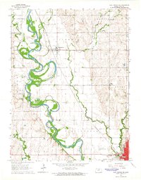 1964 Clay Center NW1965 Print · USGSClay County's river-bottom farms and rural townships are captured here in the mid-sixties as the Republican River meanders through a landscape of rail and road. Trace family roots at Swedesburg Ch or locate the old Drive-in Theater near Clay Center.
 - 1964 Map of Clay Center SW, 1965 Print
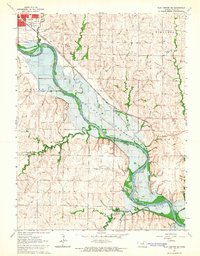
 1964 Clay Center SW1965 Print · USGSClay County at the dawn of the sixties shows a landscape of traditional farming townships meeting the rising waters of the new reservoir. Researchers can locate rural landmarks like Ladysmith, the Republican City Cem, and several country schools including Hebron Sch.
 - 1964 Map of Clay Center SE, 1965 Print
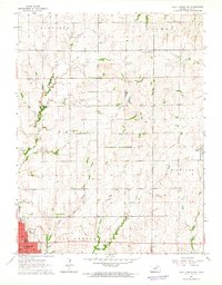
 1964 Clay Center SE1965 Print · USGSClay County's river valley was on the cusp of change in the mid-sixties as the reservoir began to reshape the landscape south of the county seat. Genealogists and local historians can trace the original location of Broughton, the Gilbert Cem, and the historic rail line of the Chicago Rock Island and Pacific.
 - 1964 Map of Clay Center NE, 1965 Print
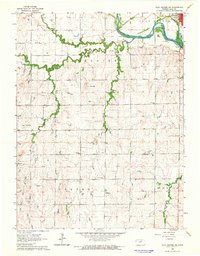
 1964 Clay Center NE1965 Print · USGSClay County at the start of the 1960s reveals a landscape of established townships and evolving transport. Genealogists and local historians can trace the Old Railroad Grade near Green or locate family sites like Hayes Cem and the Brethren in Christ Cem.
 - 1985 Map of Clay Center
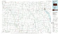 1985 Clay Center1985 Print · USGSThe river valleys of North Central Kansas appear here in the mid-eighties, showing the region's agricultural layout and the rise of Milford Lake. Researchers can trace old township connections through settlements like Delphos, Idana, and Summerville.2 unique versions available
End of results
Showing maps 1-8 of 8
Top cities near Clay Center
- Wakefield historical maps
- Bala historical maps
- Milford historical maps
- Clifton historical maps
- Morganville historical maps
- Green historical maps
See more
Frequently asked questions
- What are the different types of historical maps available for Clay Center?
- What is the oldest map of Clay Center?
- Where can I purchase historical maps of Clay Center for my home or office?
- Where can I download high-res historical maps of Clay Center?
- Are there historical topographic maps available for Clay Center?
- Is there historical aerial imagery available for Clay Center?
- Where are historical maps of Clay Center sourced from?