Old Maps of Clay County, Kansas
Explore 115 old maps of Clay County, spanning from 1886 to today. These high-resolution historic maps reveal how streets, neighborhoods, landmarks, and natural features evolved over time — perfect for genealogy, metal detecting, research, and local history exploration.
What you can do with these maps:
- See how Clay County changed over time: Compare historical maps to modern-day views to trace roads, homesites, rail lines & more.
- View detailed metadata: Each map includes creators, publishers, year, scale, and archive source.
- Overlay maps with satellite & LiDAR: Visualize the past alongside modern tools to explore terrain & human change.
- Trusted historical sources: Maps sourced from the USGS, Library of Congress, and other archives.
- Access maps your way: View online, download high-res files, or order prints for personal or research use.
Start exploring old maps of Clay County to uncover forgotten places, hidden landmarks, and the deep history beneath your feet.
Clay County, KS maps
(115)- 1886 Map of Junction City, 1960 Print
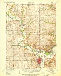
 1886 Junction City1960 Print · USGSNortheastern Kansas in the late nineteenth century centers on the strategic military and rail hubs of the Flint Hills. Genealogists can trace the early foundations of Junction City, the sprawling Fort Riley Military Reservation, and rail-stop towns like Garrison and Stockdale.
 - 1889 Map of Marysville
 1889 Marysville1889 Print · USGSMarshall County in the late nineteenth century was a bustling nexus of river trade and steam rail expansion. Genealogists and historians can trace early town sites like Marysville, Blue Rapids, and Irving along the Little Blue River and major rail lines.
 - 1889 Map of Junction City
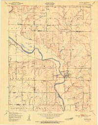
 1889 Junction City1889 Print · USGSThe confluence of the Republican and Smoky Hill rivers defines this central Kansas landscape in the late nineteenth century. Genealogists and historians can trace the early footprints of Fort Riley, the rail hubs of Junction City and Manhattan, and vanished stops like Garrison and Bala.
 - 1891 Map of Clay Center
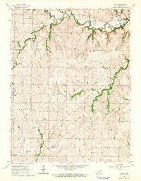
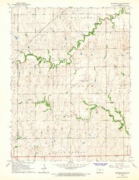
 1891 Clay Center1891 Print · USGSClay County and northern Dickinson County were defined by competing rail lines in the early 1890s as the river valleys were first being settled. Genealogists and historians can trace the early foundations of towns like Clay Center, Wakefield, and Manchester alongside the Republican River.5 unique versions available
 - 1893 Map of Washington
 1893 Washington1893 Print · USGSWashington County and its river valleys were being transformed by a massive expansion of rail lines in the 1890s. Researchers can trace the early footprints of settlements like Haddam, Clyde, and Linn along the Missouri Pacific Railway and the Republican River.4 unique versions available
 - 1894 Map of Junction City
 1894 Junction City1894 Print · USGSThe Kansas frontier of the late nineteenth century comes alive as the rail-and-river network expands around Junction City. Genealogists and historians can trace early townships and rural outposts like Riley Center, Bala, and the Fort Riley Military Reservation.7 unique versions available
 - 1894 Map of Marysville
 1894 Marysville1894 Print · USGSMarshall County's river valleys and railroad corridors are intricately detailed in the 1880s, before modern highway expansion altered the rural landscape. Genealogists can locate family lands near Ballard Falls, Bremen, or the rail junctions at Marysville.4 unique versions available
 - 1947 Map of Fort Riley, 1954 Print
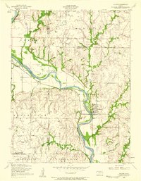
 1947 Fort Riley1954 Print · USGSPost-war Kansas comes to life where the Smoky Hill and Republican rivers meet to form the Kansas River. Genealogists and historians can trace the foundations of Fort Riley, early settlements like Milford, and dozens of rural schools including Walla Walla Sch and Acme Sch.2 unique versions available
 - 1951 Map of Milford
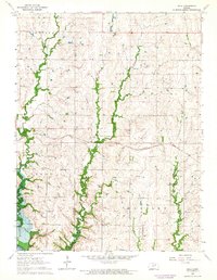
 1951 Milford1951 Print · USGSThe Republican River valley remains unchanged in this mid-century portrait of Milford before modern developments altered the local drainage. Genealogists and historians can locate rural landmarks like Acme School District 92 and the Milford Cemetery.
 - 1955 Map of Milford, 1958 Print
 1955 Milford1958 Print · USGSThe Republican River valley in the mid-1950s was a landscape of small schools and prairie churches before major reservoir projects altered the terrain. Genealogists can trace family footprints at Timber Creek Cem, Zoar School, and the Indian Grave Monument.3 unique versions available
 - 1955 Map of Manhattan, 1964 Print
 1955 Manhattan1964 Print · USGSNorth Central Kansas is captured here in the mid-fifties, just as major flood control projects began reshaping the river valleys. Genealogists can locate family sites near St. Joseph Church, Sunset Cemetery, or along the busy tracks of the Rock Island RR.4 unique versions available
 - 1956 Map of Manhattan
 1956 Manhattan1956 Print · USGSNorth-central Kansas in the mid-fifties reveals a landscape defined by the convergence of the Republican River and Smoky Hill River. Historians can trace the rail corridors of the Union Pacific RR and Missouri Pacific RR through towns like Manhattan and Clay Center.
 - 1957 Map of Manhattan
 1957 Manhattan1957 Print · USGSNortheast Kansas in the mid-1950s reveals a landscape of expanding military installations and new water projects. Genealogists and historians can trace the rail-to-river economy through the Union Pacific RR and old settlements like Clay Center or Marysville.
 - 1963 Map of Bala, 1964 Print
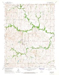
 1963 Bala1964 Print · USGSThe rural border of Riley and Clay counties is captured in the early sixties, just as the landscape prepared for major inundation. Genealogists and local historians can trace family roots at Bala Cem, the Bethany Ch, or the site of Grange Hall.2 unique versions available
 - 1963 Map of Lasita, 1965 Print
 1963 Lasita1965 Print · USGSThe rural landscape along the Clay and Riley County line is captured here in the early sixties, showing the agricultural heartland before modern consolidation. Genealogists can locate family landmarks like Ebenezer Cem, May Day Cem, and the path of the Old Railroad Grade.2 unique versions available
 - 1964 Map of Industry
 1964 Industry1964 Print · USGSAgricultural life in central Kansas during the early sixties is centered on the winding path of Chapman Creek and the settlement of Industry. Genealogists can trace local roots through numerous rural landmarks like Athelstane Cem, Bethany Chapel, and Vinzant Sch.2 unique versions available
 - 1964 Map of Clay Center NW, 1965 Print
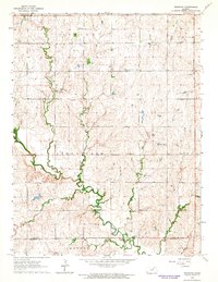
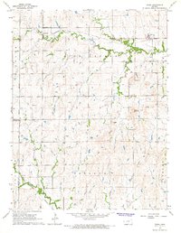
 1964 Clay Center NW1965 Print · USGSClay County's river-bottom farms and rural townships are captured here in the mid-sixties as the Republican River meanders through a landscape of rail and road. Trace family roots at Swedesburg Ch or locate the old Drive-in Theater near Clay Center.
 - 1964 Map of Clay Center SW, 1965 Print
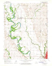
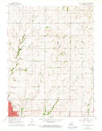
 1964 Clay Center SW1965 Print · USGSClay County at the dawn of the sixties shows a landscape of traditional farming townships meeting the rising waters of the new reservoir. Researchers can locate rural landmarks like Ladysmith, the Republican City Cem, and several country schools including Hebron Sch.
 - 1964 Map of Clay Center SE, 1965 Print
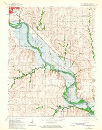 1964 Clay Center SE1965 Print · USGSClay County's river valley was on the cusp of change in the mid-sixties as the reservoir began to reshape the landscape south of the county seat. Genealogists and local historians can trace the original location of Broughton, the Gilbert Cem, and the historic rail line of the Chicago Rock Island and Pacific.
 - 1964 Map of Clay Center NE, 1965 Print
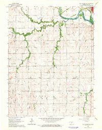
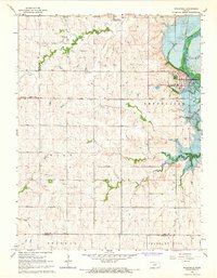
 1964 Clay Center NE1965 Print · USGSClay County at the start of the 1960s reveals a landscape of established townships and evolving transport. Genealogists and local historians can trace the Old Railroad Grade near Green or locate family sites like Hayes Cem and the Brethren in Christ Cem.
 - 1964 Map of Wakefield, 1966 Print
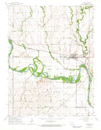
 1964 Wakefield1966 Print · USGSWakefield and the Republican River valley are shown in the mid-1960s as the landscape prepared for the rising waters of the Milford Reservoir. Genealogists and local historians can locate the Peaceful Valley Sch, St Johns Cem, and Uniondale Ch before several low-lying areas were submerged.
 - 1964 Map of Idana, 1966 Print
 1964 Idana1966 Print · USGSClay and Ottawa counties are captured here in the mid-1960s, showing a rural landscape of winding creek beds and traditional townships. Genealogists can locate family landmarks like Shields Cem, Browndale Sch, and the quiet settlement of Idana.
 - 1964 Map of Miltonvale NE, 1966 Print
 1964 Miltonvale NE1966 Print · USGSThe rural landscape of northern Clay County is captured in the mid-1960s, showing a transition of prairie drainages and township lines. Researchers can pinpoint specific local sites like the Lincoln Community Hall, Bloom Cem, and the winding Mulberry Creek.
 - 1965 Map of Clifton, 1966 Print
 1965 Clifton1966 Print · USGSThe Republican River valley in the mid-1960s reveals a landscape where the Chicago Rock Island and Pacific railroad links the communities of Clifton and Vining. Local historians can trace cemetery locations like St Marys Cem and follow the winding courses of Dry Creek and Scribner Creek.
 - 1965 Map of Longford, 1966 Print
 1965 Longford1966 Print · USGSThe Kansas prairie near the Clay and Ottawa county lines is captured here in the mid-sixties, anchored by the town of Longford. Family historians can trace local roots through several rural burial grounds like Swartwood Cem and old landmarks like Walker Sch.
Showing maps 1-25 of 115
Top cities of Clay County
- Clay Center historical maps
- Wakefield historical maps
- Morganville historical maps
- Green historical maps
- Longford historical maps
- Oak Hill historical maps
Frequently asked questions
- What are the different types of historical maps available for Clay County?
- What is the oldest map of Clay County?
- Where can I purchase historical maps of Clay County for my home or office?
- Where can I download high-res historical maps of Clay County?
- Are there historical topographic maps available for Clay County?
- Is there historical aerial imagery available for Clay County?
- Where are historical maps of Clay County sourced from?