
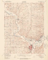
1947 Map of Fort Riley
USGS Topo · Published 1954About this map
The Fort Riley Military Reservation dominates the landscape of north-central Kansas on this 1947 survey, where the Republican River and Kansas River converge. The military presence is extensive, featuring major installations such as Camp Forsyth, Camp Whiteside, and Marshall Air Force Base, alongside specialized training areas like the Vehicle Firing Range and Moving Target zones. The topographic detail captures the varied terrain of Seven Mile and Ogden, including prominent elevations like Morris Hill and 22nd Battery Hill.
Find a feature on this map
70 named features on this map. Tap any name to fly to it.
Don’t see what you’re looking for? This feature index may not catch every label — zoom into the map to look around manually.
Map Details
Editions of this 1947 Fort Riley Map
2 editions found
Other maps of this area

1886 · Junction City
USGS Topo · 1:125,000

1889 · Junction City
USGS Topo · 1:125,000

1889 · Abilene
USGS Topo · 1:125,000

1889 · Parkerville
USGS Topo · 1:125,000

1891 · Clay Center
USGS Topo · 1:125,000

1894 · Junction City
USGS Topo · 1:125,000

1894 · Abilene
USGS Topo · 1:125,000

1894 · Parkerville
USGS Topo · 1:125,000

1947 · Manhattan
USGS Topo · 1:62,500

1950 · Keats
USGS Topo · 1:24,000