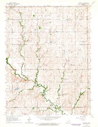
1964 Map of Industry
USGS Topo · Published 1964About this map
Chapman Creek meanders through the heart of this agricultural region on the border of Clay and Dickinson counties, anchoring a landscape defined by small rural school districts and community hubs. The map illustrates a mid-century pattern of upland farming and drainage basins, where watercourses like Basket Creek and Otter Creek dictate the local topography. Local history and genealogy are deeply rooted in the various namesake structures found throughout the townships, including Bethany Chapel in the northwest and Industry to the south. Educational centers of a previous era are still noted on the landscape, with Tubbs Sch, Vinzant Sch, and Athelstane Sch marking the centers of their respective rural neighborhoods. The township of Athelstane also contains the Athelstane Cem, a vital point of reference for families tracing their lineage in this part of Kansas.
Find a feature on this map
16 named features on this map. Tap any name to fly to it.
Don’t see what you’re looking for? This feature index may not catch every label — zoom into the map to look around manually.
Map Details
Editions of this 1964 Industry Map
2 editions found
Other maps of this area

1891 · Clay Center
USGS Topo · 1:125,000

1955 · Manhattan
USGS Topo · 1:250,000

1956 · Manhattan
USGS Topo · 1:250,000

1957 · Manhattan
USGS Topo · 1:250,000
1963 · Upland
USGS Topo · 1:24,000
1964 · Buckeye
USGS Topo · 1:24,000

1964 · Clay Center SW
USGS Topo · 1:24,000
1964 · Clay Center SE
USGS Topo · 1:24,000
1964 · Wakefield
USGS Topo · 1:24,000

1964 · Idana
USGS Topo · 1:24,000