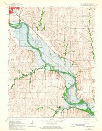
1964 Map of Clay Center SE
USGS Topo · Published 1965About this map
The Republican River valley south of Clay Center undergoes a major transformation in the mid-1960s as the Milford Reservoir begins to take shape. This survey documents the landscape just as rising waters were slated to alter the terrain, showing the original paths of the Chicago Rock Island and Pacific railroad and the small settlement of Broughton. Beyond the immediate floodplain, the map captures established rural landmarks including Lincoln Sch and several local burial grounds such as Gilbert Cem and Gatesville Cem. The northern edge of the sheet provides a detailed layout of Clay Center, featuring Dexter Park, the Fairground, and various municipal facilities. The transition from the high ground of Highland down to the creek-fed bottoms of Otter Creek and Cane Creek illustrates the agricultural and hydrological character of this Kansas region before the full inundation of the reservoir.
Find a feature on this map
24 named features on this map. Tap any name to fly to it.
Don’t see what you’re looking for? This feature index may not catch every label — zoom into the map to look around manually.
Map Details
Editions of this 1964 Clay Center SE Map
This is the sole edition of this map. No revisions or reprints were ever made.
Other maps of this area

1886 · Junction City
USGS Topo · 1:125,000

1889 · Junction City
USGS Topo · 1:125,000

1891 · Clay Center
USGS Topo · 1:125,000

1894 · Junction City
USGS Topo · 1:125,000

1947 · Fort Riley
USGS Topo · 1:62,500

1951 · Milford
USGS Topo · 1:24,000

1955 · Milford
USGS Topo · 1:24,000

1955 · Manhattan
USGS Topo · 1:250,000

1956 · Manhattan
USGS Topo · 1:250,000

1957 · Manhattan
USGS Topo · 1:250,000