1960s Maps of Crawford County, Kansas
Explore 4 historic maps of Crawford County from the 1960s. These maps offer a rare glimpse into what life looked like during the 1960s — showing old roads, neighborhoods, homes, and landmarks that have changed or disappeared over time.
Whether you're researching your family's past, planning a metal detecting trip, or studying how Crawford County's landscape evolved across the 1960s, these high-resolution maps are a powerful tool for exploring the history of this region.
- Focus on a specific era: All maps on this page are from the 1960s, giving you a focused view of this time period.
- See what’s changed: Compare century-old streets, trails, and buildings to today's modern landscape using overlays and satellite layers.
- Research with precision: Use these maps for genealogy, historical research, land use analysis, or educational projects.
- View, download, or print: Maps are fully viewable online in high resolution, and can be downloaded or printed for your own records.
Start exploring Crawford County's history through authentic maps from the 1960s. This is your window into the past.
Crawford County, KS maps
(4)- 1964 Map of Radley
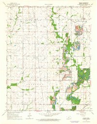 1964 Radley1964 Print · USGSCrawford County was a hub of industrial activity in the 1960s as coal extraction reshaped the prairie landscape. Genealogists and researchers can trace local roots at Beulah Cem, follow old rail lines like the Missouri Pacific Railroad, or locate the Childrens Home.2 unique versions available
 - 1964 Map of Cherokee, 1965 Print
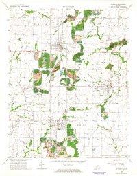 1964 Cherokee1965 Print · USGSSoutheast Kansas in the mid-1960s reveals a landscape shaped by coal and rail. Genealogists and historians can trace the foundations of Cherokee, Weir, and Scammon alongside numerous parish sites like St Bridget Cem and St Anthony Cem.
 - 1964 Map of Hiattville, 1965 Print
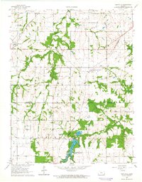 1964 Hiattville1965 Print · USGSBourbon and Crawford counties are shown here in the mid-1960s, a landscape shaped by rail lines and the winding tributaries of the Pawnee. Researchers can locate the Fairview School, the Farlington Cem, and the specialized Fish Hatchery near Farlington Lake.
 - 1964 Map of Girard, 1965 Print
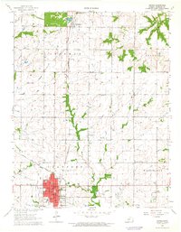 1964 Girard1965 Print · USGSSoutheast Kansas in the mid-sixties reveals a landscape defined by the intersection of major rail lines and rural township life. Genealogists and local historians can trace the foundations of Girard and Ringo, or locate ancestral sites near Farlington Cem and Union Center Cem.
End of results
Showing maps 1-4 of 4
Top cities of Crawford County
- Pittsburg historical maps
- Frontenac historical maps
- Girard historical maps
- Arma historical maps
- Cherokee historical maps
- Mulberry historical maps
See more
Frequently asked questions
- What are the different types of historical maps available for Crawford County?
- What is the oldest map of Crawford County?
- Where can I purchase historical maps of Crawford County for my home or office?
- Where can I download high-res historical maps of Crawford County?
- Are there historical topographic maps available for Crawford County?
- Is there historical aerial imagery available for Crawford County?
- Where are historical maps of Crawford County sourced from?