1970s Maps of Crawford County, Kansas
Explore 8 historic maps of Crawford County from the 1970s. These maps offer a rare glimpse into what life looked like during the 1970s — showing old roads, neighborhoods, homes, and landmarks that have changed or disappeared over time.
Whether you're researching your family's past, planning a metal detecting trip, or studying how Crawford County's landscape evolved across the 1970s, these high-resolution maps are a powerful tool for exploring the history of this region.
- Focus on a specific era: All maps on this page are from the 1970s, giving you a focused view of this time period.
- See what’s changed: Compare century-old streets, trails, and buildings to today's modern landscape using overlays and satellite layers.
- Research with precision: Use these maps for genealogy, historical research, land use analysis, or educational projects.
- View, download, or print: Maps are fully viewable online in high resolution, and can be downloaded or printed for your own records.
Start exploring Crawford County's history through authentic maps from the 1970s. This is your window into the past.
Crawford County, KS maps
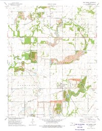
(8)- 1973 Map of Walnut, 1975 Print
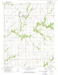 1973 Walnut1975 Print · USGSSoutheast Kansas prairie life is captured here in the early 1970s, where the town of Walnut served as a dual-railroad crossroads. Researchers can locate family sites near Glenwood Cem, trace the historic Indian Treaty Boundary, or survey the active Oil Field and Grange Hall.
 - 1973 Map of Porterville, 1975 Print
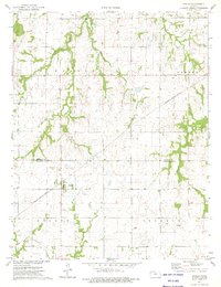
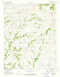 1973 Porterville1975 Print · USGSSoutheastern Kansas in the early 1970s remains a landscape of traditional farmsteads and growing energy extraction. Researchers can trace the Old Indian Treaty Boundary and locate family sites near Harmony Cem or the rural outpost of Porterville.
 - 1973 Map of Mc Cune NE, 1975 Print
 1973 Mc Cune NE1975 Print · USGSSoutheast Kansas in the early seventies shows a landscape where active extraction and conservation meet at the junction of three counties. Genealogists and historians can trace rural landmarks like Valley City Cem, Green Elm Ch, and the oxbows of Halfmoon Lake.2 unique versions available
 - 1973 Map of Brazilton, 1975 Print
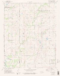
 1973 Brazilton1975 Print · USGSCrawford County's rural landscape is captured here in the early seventies, centered on the railroad crossing at Brazilton. Researchers can trace local lineage through sites like Greenbush, Mills Cem, and the Lutheran Sch located near the town center.
 - 1973 Map of West Mineral, 1975 Print
 1973 West Mineral1975 Print · USGSCherokee County’s coal mining landscape is on full display in the 1970s as industrial excavations reshape the Kansas plains. Genealogists and historians can locate family plots at Star Cem and Bowen Cem or trace the busy Missouri Pacific rail line.
 - 1973 Map of Hepler, 1975 Print
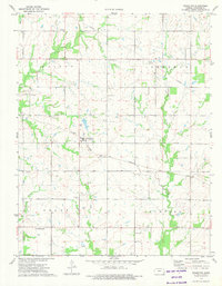
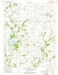
 1973 Hepler1975 Print · USGSHepler and the border of Bourbon and Crawford Counties are captured in the early seventies as the rail-and-creek economy shaped the local landscape. Genealogists and historians can trace the Missouri - Kansas - Texas rail line and locate rural burial sites such as St Mary Cem and Hiattville Cem.
 - 1973 Map of Mc Cune, 1975 Print
 1973 Mc Cune1975 Print · USGSSoutheast Kansas in the early 1970s reveals a landscape shaped by the Neosho River and the industrial reach of the St Louis - San Francisco railroad. Researchers can locate the rural Service Valley Sch, several family cemeteries, and old mining sites like the southern Strip Mine.
 - 1973 Map of Grindstone Creek, 1975 Print
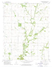 1973 Grindstone Creek1975 Print · USGSCrawford County's rural townships are captured here in the early 1970s, showcasing a landscape of small agricultural settlements and active resource extraction. Researchers can locate vanished landmarks and family sites like Greenbush, Mt Carmel Cem, and the Strip Mine south of Osage Ch.
End of results
Showing maps 1-8 of 8
Top cities of Crawford County
- Pittsburg historical maps
- Frontenac historical maps
- Girard historical maps
- Arma historical maps
- Cherokee historical maps
- Mulberry historical maps
See more
Frequently asked questions
- What are the different types of historical maps available for Crawford County?
- What is the oldest map of Crawford County?
- Where can I purchase historical maps of Crawford County for my home or office?
- Where can I download high-res historical maps of Crawford County?
- Are there historical topographic maps available for Crawford County?
- Is there historical aerial imagery available for Crawford County?
- Where are historical maps of Crawford County sourced from?