1990s Maps of Elk County, Kansas
Explore 3 historic maps of Elk County from the 1990s. These maps offer a rare glimpse into what life looked like during the 1990s — showing old roads, neighborhoods, homes, and landmarks that have changed or disappeared over time.
Whether you're researching your family's past, planning a metal detecting trip, or studying how Elk County's landscape evolved across the 1990s, these high-resolution maps are a powerful tool for exploring the history of this region.
- Focus on a specific era: All maps on this page are from the 1990s, giving you a focused view of this time period.
- See what’s changed: Compare century-old streets, trails, and buildings to today's modern landscape using overlays and satellite layers.
- Research with precision: Use these maps for genealogy, historical research, land use analysis, or educational projects.
- View, download, or print: Maps are fully viewable online in high resolution, and can be downloaded or printed for your own records.
Start exploring Elk County's history through authentic maps from the 1990s. This is your window into the past.
Elk County, KS maps
(3)- 1990 Map of Chanute
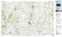 1990 Chanute1990 Print · USGSSoutheast Kansas at the start of the nineties reveals a landscape of river-valley towns and agricultural hubs. Researchers can trace the paths of the Missouri Pacific RR through Iola or locate family roots near Savonburg, Thayer, and Buffalo.
 - 1990 Map of El Dorado
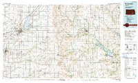 1990 El Dorado1990 Print · USGSButler and Greenwood counties are shown here in the early nineties, featuring a landscape defined by the Walnut River basin and the Kansas Turnpike corridor. Researchers can trace the rail lines of the AT & SF RR and locate smaller settlements such as Midian, Smileyberg, and Pickrell Corner.
 - 1990 Map of Coffeyville
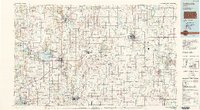 1990 Coffeyville1990 Print · USGSSoutheast Kansas in the late twentieth century is defined by its industrial sites and river valley rail hubs. Genealogists and historians can trace the infrastructure of the Army Ammunition Plant, the local graves at Fairview Cemetery, and the extensive Strip Mine operations.
End of results
Showing maps 1-3 of 3
Top cities of Elk County
- Howard historical maps
- Moline historical maps
- Longton historical maps
- Grenola historical maps
- Oak Valley historical maps
- Elk Falls historical maps
Frequently asked questions
- What are the different types of historical maps available for Elk County?
- What is the oldest map of Elk County?
- Where can I purchase historical maps of Elk County for my home or office?
- Where can I download high-res historical maps of Elk County?
- Are there historical topographic maps available for Elk County?
- Is there historical aerial imagery available for Elk County?
- Where are historical maps of Elk County sourced from?