1960s Maps of Dodge City, Kansas
Explore 3 historic maps of Dodge City from the 1960s. These maps offer a rare glimpse into what life looked like during the 1960s — showing old roads, neighborhoods, homes, and landmarks that have changed or disappeared over time.
Whether you're researching your family's past, planning a metal detecting trip, or studying how Dodge City's landscape evolved across the 1960s, these high-resolution maps are a powerful tool for exploring the history of this region.
- Focus on a specific era: All maps on this page are from the 1960s, giving you a focused view of this time period.
- See what’s changed: Compare century-old streets, trails, and buildings to today's modern landscape using overlays and satellite layers.
- Research with precision: Use these maps for genealogy, historical research, land use analysis, or educational projects.
- View, download, or print: Maps are fully viewable online in high resolution, and can be downloaded or printed for your own records.
Start exploring Dodge City's history through authentic maps from the 1960s. This is your window into the past.
Dodge City, KS maps
(3)- 1968 Map of Dodge City, 1969 Print
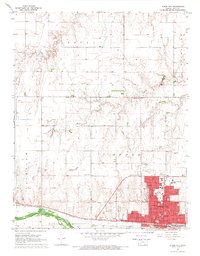 1968 Dodge City1969 Print · USGSDodge City thrived along the Arkansas River in the late sixties as a regional hub of education and transport. Researchers can locate Boot Hill, trace the Old Indian Treaty Boundary, and identify schools like Sacred Heart Sch.3 unique versions available
 - 1969 Map of South Dodge, 1971 Print
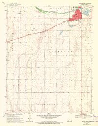 1969 South Dodge1971 Print · USGSFord County south of the Arkansas River in the late sixties shows a mix of industrial expansion and traditional farm life. Genealogists and historians can trace the Old Indian Treaty Boundary or find rural landmarks like Richland Valley Sch and Hope Ch.3 unique versions available
 - 1969 Map of Fort Dodge, 1971 Print
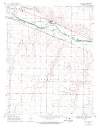 1969 Fort Dodge1971 Print · USGSFort Dodge and the Arkansas River valley are captured in the late sixties as industrial transport and rural settlements defined the Ford County landscape. Researchers can trace the dual rail lines of the Atchison Topeka and Santa Fe and the Chicago Rock Island and Pacific near Wilroads Gardens.2 unique versions available
End of results
Showing maps 1-3 of 3
Top cities near Dodge City
Top neighborhoods of Dodge City
Frequently asked questions
- What are the different types of historical maps available for Dodge City?
- What is the oldest map of Dodge City?
- Where can I purchase historical maps of Dodge City for my home or office?
- Where can I download high-res historical maps of Dodge City?
- Are there historical topographic maps available for Dodge City?
- Is there historical aerial imagery available for Dodge City?
- Where are historical maps of Dodge City sourced from?