Old Maps of Franklin County, Kansas for Academic Research
Study the evolution of Franklin County with 105 high-resolution historic maps. Whether you're teaching, researching, or modeling changes in land use, these maps provide essential visual documentation of urban, environmental, and geographic change.
- Analyze long-term change: Track patterns in development, transportation, and natural features.
- Ideal for environmental or urban studies: Support academic projects with primary historical map data.
- Use in the classroom or lab: Educators and researchers rely on these maps to bring historical context to life.
These maps are a powerful tool for teaching, research, and visualizing how Franklin County has changed over the decades.
Franklin County, KS maps
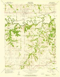
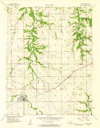
(105)- 1885 Map of Burlington
 1885 Burlington1885 Print · USGSCoffey County was a hub of steam and steel in the 1880s, where several competing rail lines converged on the river valley. You can trace early family homesteads near Burlington, the small settlement of Bellgrade, and the junctions of the Kansas Southern Railroad.
 - 1885 Map of Garnett
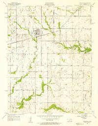
 1885 Garnett1885 Print · USGSAnderson County during the late nineteenth-century rail boom shows a landscape of emerging towns and heavy steam-engine influence. Genealogists can trace family roots in early settlements like Garnett, Central City, and Elizabethtown before the modern highway era.
 - 1885 Map of Lawrence, 1957 Print
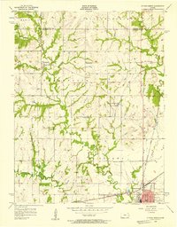
 1885 Lawrence1957 Print · USGSEastern Kansas thrived during the mid-1880s as a vital corridor of rail-driven commerce and river valley agriculture. Genealogists and historians can trace old homesteads near the Kansas River and identify early township centers like Ottawa, Eudora, and Vinland.
 - 1889 Map of Burlingame
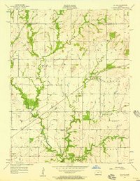
 1889 Burlingame1889 Print · USGSOsage and Shawnee Counties are seen here during the peak of late-Victorian rail expansion and coal-country growth. Genealogists and local historians can trace early township boundaries and the development of rail hubs like Osage City, Burlingame, and the settlement of Arvonia.
 - 1889 Map of Lawrence
 1889 Lawrence1889 Print · USGSEastern Kansas thrived as a rail-and-river hub in the late nineteenth century, as documented in this detailed survey. Genealogists can trace family roots through early settlements like Clinton, Vinland, and Eudora or locate land near the Marais Des Cygnes River.6 unique versions available
 - 1894 Map of Garnett
 1894 Garnett1894 Print · USGSAnderson County and its neighbors flourished during this Victorian-era railroad boom. Genealogists and historians can trace the exact routes of the Missouri Pacific Railroad and locate early settlements like Elizabethtown, Central City, and Mont Ida.5 unique versions available
 - 1894 Map of Burlingame
 1894 Burlingame1894 Print · USGSOsage County was a thriving rail and coal hub in the late nineteenth century, dominated by the intersecting tracks of major regional carriers. Researchers can trace the development of early Kansas towns like Scranton, Carbondale, and the river community of Quenemo.4 unique versions available
 - 1894 Map of Burlington
 1894 Burlington1894 Print · USGSCoffey County was a bustling intersection of iron and water in the 1880s, where the Neosho River met multiple competing railroads. Genealogists can trace family footprints in early settlements like Burlington, Leroy, and the Welsh community of Arvonia.5 unique versions available
 - 1947 Map of Lawrence, 1954 Print
 1947 Lawrence1954 Print · USGSEastern Kansas and western Missouri thrive in the late 1940s, showing a landscape defined by major river valleys and a dense railway network. Genealogists can trace family settlements from Lawrence to Greenwood and locate landmarks like Olathe Navy and Lake Lotawana.
 - 1950 Map of Lawrence
 1950 Lawrence1950 Print · USGSMid-century Kansas and Missouri come alive in this map of the river-valley corridors just as the interstate era was beginning. Researchers can trace the legacy of major rail lines like the Union Pacific RR and locate ancestral roots in towns from Lawrence to Harrisonville.
 - 1956 Map of Pomona, 1957 Print
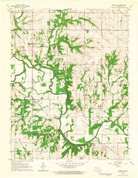
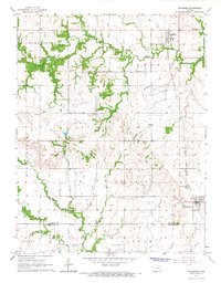
 1956 Pomona1957 Print · USGSFranklin County's agricultural and rail landscape is captured here in the mid-1950s, centered on the oxbows of the Marais Des Cygnes River. Genealogists and local historians can trace old school districts like South Illinois Sch or follow the Atchison Topeka and Santa Fe line through Richter and Pomona.2 unique versions available
 - 1956 Map of Wellsville, 1957 Print
 1956 Wellsville1957 Print · USGSWellsville was a thriving railroad and agricultural hub in the mid-1950s, centered on the Santa Fe and Topeka Atchison line. Genealogists and historians can trace rural family roots through the Rock Creek Sch and cemeteries like Walnut Creek Cem.2 unique versions available
 - 1956 Map of Ottawa North, 1957 Print
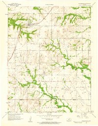
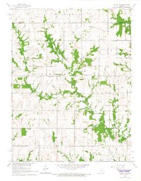
 1956 Ottawa North1957 Print · USGSFranklin County in the mid-fifties shows a landscape of small rural schoolhouses and historic rail junctions. Genealogists can trace family roots through sites like Mt Evergreen Cem, Centropolis, and the Old Indian Boundary line.3 unique versions available
 - 1956 Map of Le Loup, 1957 Print
 1956 Le Loup1957 Print · USGSThe rural landscape of Franklin County is captured here in the mid-1950s, where the railroad ties together farming communities and small country schools. Researchers can trace the Old Indian Boundary or locate historic sites like Indian Cem, Tauy Ch, and Le Loup.2 unique versions available
 - 1956 Map of Williamsburg, 1958 Print
 1956 Williamsburg1958 Print · USGSWilliamsburg and Silkville appear in the mid-fifties at a time when the railroad still anchored the life of these eastern Kansas townships. Genealogists can trace family sites at Mt Hope Cem and St Patricks Sch, or follow the diagonal of the Old Indian Boundary.3 unique versions available
 - 1956 Map of Ottawa South, 1958 Print
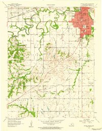 1956 Ottawa South1958 Print · USGSOttawa and the surrounding Franklin County townships are captured here during a period of steady mid-century growth. Genealogists and local historians can trace rural schoolhouses like Valley View Sch, family landmarks such as Wycoff Community Hall, and several burial grounds including Highland Cemetery and Antioch Cem.4 unique versions available
 - 1956 Map of Lawrence, 1967 Print
 1956 Lawrence1967 Print · USGSEastern Kansas and the Missouri border country are captured here during the mid-century transition to the interstate era. Genealogists and local historians can trace family-named terrain like Summers Mound and the footprint of Sunflower Ordnance Works near Baldwin City.4 unique versions available
 - 1957 Map of Waverly, 1958 Print
 1957 Waverly1958 Print · USGSCoffey County in the late 1950s was a landscape defined by the prairie-spanning rails and rural crossroads. Local researchers can trace family landmarks like Boothe Hall, Rosemont Ch, and the historical path of the Old Indian Boundary.2 unique versions available
 - 1961 Map of Lawrence
 1961 Lawrence1961 Print · USGSThe Kansas-Missouri borderland shows its mid-century transition from a rail-dependent agricultural region to a suburbanizing landscape. Genealogists can trace family footprints through numerous Cem sites and distinctive terrain landmarks like Graves Mound and Summers Mound.
 - 1962 Map of Peoria, 1964 Print
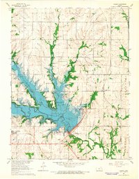
 1962 Peoria1964 Print · USGSFranklin County in the early sixties reveals a landscape shaped by the Marais Des Cygnes River and old frontier borders. Genealogists can trace family names through the Peoria Cem, Fouts Cem, and Highland Cem, or locate rural landmarks like the Hawkins Sch.2 unique versions available
 - 1963 Map of Rantoul, 1964 Print
 1963 Rantoul1964 Print · USGSEastern Kansas agriculture and river life are preserved here in the early sixties, centered on the village of Rantoul. Researchers can trace the path of the Missouri Pacific railroad and locate rural landmarks like New Hope Ch and Howard Cem.2 unique versions available
 - 1965 Map of Ottawa NW, 1966 Print
 1965 Ottawa NW1966 Print · USGSThe rural townships of Franklin and Douglas counties are captured here in the mid-1960s. Researchers can locate several burial sites and rural centers like Appanoose Cem, Eightmile Ch, and the Old Indian Treaty Boundary.2 unique versions available
 - 1965 Map of Vassar, 1966 Print
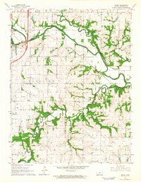
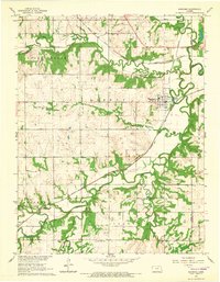
 1965 Vassar1966 Print · USGSOsage County was undergoing a major geographic shift in the mid-sixties as the newly filled Pomona Reservoir reshaped the local valleys. Researchers can trace the legacy of the MISSOURI PACIFIC railroad through Vassar or locate historic burial sites like Mt Zion Cem.2 unique versions available
 - 1965 Map of Quenemo, 1966 Print
 1965 Quenemo1966 Print · USGSOsage County agricultural and rail life is captured here in the mid-1960s, centered on the river-fed plains around Quenemo. Genealogists can locate several family burial grounds like Curry Cem and Sutton Cem near the winding Marais des Cygnes River.
 - 1965 Map of Richmond, 1967 Print
 1965 Richmond1967 Print · USGSThe Kansas prairie south of Ottawa comes alive in the mid-sixties, anchored by the rail-side towns of Princeton and Richmond. Genealogists and local historians can locate rural landmarks like Mt Olivet Ch, Acorn Community Hall, and the winding Old Channel Sac Creek.2 unique versions available
Showing maps 1-25 of 105
Top cities of Franklin County
- Ottawa historical maps
- Wellsville historical maps
- Centropolis historical maps
- Pomona historical maps
- Pomona historical maps
- Peoria historical maps
See more
Frequently asked questions
- What are the different types of historical maps available for Franklin County?
- What is the oldest map of Franklin County?
- Where can I purchase historical maps of Franklin County for my home or office?
- Where can I download high-res historical maps of Franklin County?
- Are there historical topographic maps available for Franklin County?
- Is there historical aerial imagery available for Franklin County?
- Where are historical maps of Franklin County sourced from?