1960s Maps of Harvey County, Kansas
Explore 5 historic maps of Harvey County from the 1960s. These maps offer a rare glimpse into what life looked like during the 1960s — showing old roads, neighborhoods, homes, and landmarks that have changed or disappeared over time.
Whether you're researching your family's past, planning a metal detecting trip, or studying how Harvey County's landscape evolved across the 1960s, these high-resolution maps are a powerful tool for exploring the history of this region.
- Focus on a specific era: All maps on this page are from the 1960s, giving you a focused view of this time period.
- See what’s changed: Compare century-old streets, trails, and buildings to today's modern landscape using overlays and satellite layers.
- Research with precision: Use these maps for genealogy, historical research, land use analysis, or educational projects.
- View, download, or print: Maps are fully viewable online in high resolution, and can be downloaded or printed for your own records.
Start exploring Harvey County's history through authentic maps from the 1960s. This is your window into the past.
Harvey County, KS maps
(5)- 1962 Map of Whitewater, 1963 Print
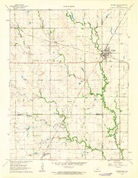 1962 Whitewater1963 Print · USGSButler and Harvey Counties thrive as a rail and agricultural crossroads in the early sixties, centered on the junction at Whitewater. Researchers can trace old property lines, local cemeteries like Swiss Cem, and the path of the Missouri Pacific railroad.2 unique versions available
 - 1965 Map of Goessel, 1966 Print
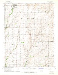 1965 Goessel1966 Print · USGSMarion and Harvey counties appear in the mid-1960s as a structured agricultural landscape centered on the town of Goessel. Genealogists and local historians can trace rural roots through landmarks like Highland Ch, Grange Hall, and Greenfield Cem.
 - 1965 Map of Halstead NW, 1966 Print
 1965 Halstead NW1966 Print · USGSCentral Kansas farm country across McPherson and Harvey counties is captured here in the mid-sixties, showing a landscape defined by prairie streams and section roads. Genealogists can trace family footprints through numerous local sites like Hoffnungsau Ch, Hebron Cem, and the Turkey Creek Sch.
 - 1965 Map of Hesston, 1966 Print
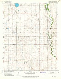
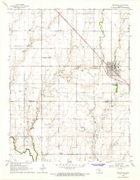
 1965 Hesston1966 Print · USGSHesston and its surrounding Kansas farmland are shown in the mid-sixties, capturing the intersection of academic life and the railroad economy. Researchers can locate family roots at Hesston College, Meridian Ch, or the Freedom Cem while tracing the Missouri Pacific rail corridor.2 unique versions available
 - 1965 Map of Moundridge, 1966 Print
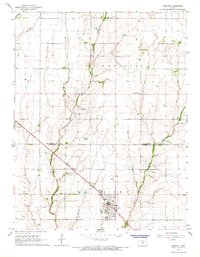
 1965 Moundridge1966 Print · USGSMoundridge and the surrounding prairie of McPherson and Harvey Counties are shown in the mid-1960s as a well-established rail and agricultural community. Researchers can trace the layout of rural life through sites like Cloverleaf Sch, Eden Ch, and the Missouri Pacific rail line.2 unique versions available
End of results
Showing maps 1-5 of 5
Top cities of Harvey County
- Newton historical maps
- Hesston historical maps
- Halstead historical maps
- Sedgwick historical maps
- North Newton historical maps
- Burrton historical maps
See more
Frequently asked questions
- What are the different types of historical maps available for Harvey County?
- What is the oldest map of Harvey County?
- Where can I purchase historical maps of Harvey County for my home or office?
- Where can I download high-res historical maps of Harvey County?
- Are there historical topographic maps available for Harvey County?
- Is there historical aerial imagery available for Harvey County?
- Where are historical maps of Harvey County sourced from?