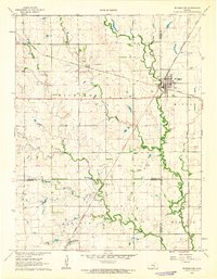
1962 Map of Whitewater
USGS Topo · Published 1963About this map
The town of Whitewater serves as a central hub on this 1960s Kansas landscape, where the Missouri Pacific and Chicago Rock Island and Pacific railroads intersect. This convergence of rail lines underscores the area's historical importance as a transport link for the surrounding agricultural townships of Richland, Milton, Lincoln, and Murdock. The terrain is defined by the winding course of the West Branch Whitewater River and its various tributaries, such as Gypsum Creek and Wildcat Creek, which carve through the plains. Local history is anchored by several burial grounds, including Swiss Cem, Whitewater Cem, and Green Valley Cem. Beyond farming, the presence of numerous Oil Wells scattered across the southern sections points to the region's mid-century energy production. Smaller communities like Annelly and Furley are also documented, alongside municipal landmarks such as a Water Tank and Sewage Disposal site.
Find a feature on this map
26 named features on this map. Tap any name to fly to it.
Don’t see what you’re looking for? This feature index may not catch every label — zoom into the map to look around manually.
Map Details
Editions of this 1962 Whitewater Map
2 editions found
Other maps of this area

1889 · Newton
USGS Topo · 1:125,000

1889 · Wichita
USGS Topo · 1:125,000

1894 · Wichita
USGS Topo · 1:125,000

1894 · Newton
USGS Topo · 1:125,000

1941 · Valley Center
USGS Topo · 1:31,680

1942 · Valley Center
USGS Topo · 1:31,680

1955 · Benton
USGS Topo · 1:24,000

1955 · Greenwich
USGS Topo · 1:24,000

1955 · Wichita
USGS Topo · 1:250,000

1955 · Hutchinson
USGS Topo · 1:250,000