1889 Map of Wichita
USGS Topo · Published 1889About this map
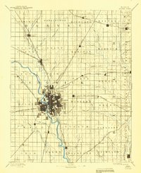
Wichita sits at the vital confluence of the Little Arkansas River and the Arkansas River, serving as a massive hub for five major rail lines in the late 1880s. The city's grid-like expansion is already evident, surrounded by a productive landscape divided into townships like Delano, Minneha, and Waco. This survey captures the region just as the "Wheat State's" rail infrastructure reached its peak, with the Atchison Topeka and Santa Fe Railroad and the Missouri Pacific Railroad threading through dozens of small prairie stations.
Find a feature on this map
77 named features on this map. Tap any name to fly to it.
Don’t see what you’re looking for? This feature index may not catch every label — zoom into the map to look around manually.
Map Details
Editions of this 1889 Wichita Map
This is the sole edition of this map. No revisions or reprints were ever made.
Historical Maps of Wichita Through Time
6 maps found