
1893 Map of Caldwell
USGS Topo · Published 1893About this map
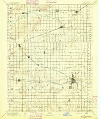
The Chicaskia River and Bluff Creek carve through the prairie landscape of south-central Kansas in the late nineteenth century. This era of settlement is defined by a dense web of competing rail lines, including the Atchison Topeka and Santa Fe Railroad and the Missouri Pacific Railroad, which dictated the growth of agriculture and commerce in the region. The map reveals the early town plats of Caldwell, Conway Springs, and Argonia, which served as vital shipping points for the surrounding townships. Smaller rail stops and crossroads such as Anness, Ewell, and Blackstone appear as they did before the consolidation of rural communities. The intricate network of drainage, from Deer Creek to Wild Cat Creek, illustrates the natural hydrology that influenced early homesteading patterns and the placement of bridges across the Sumner and Harper county lines.
Find a feature on this map
81 named features on this map. Tap any name to fly to it.
Don’t see what you’re looking for? This feature index may not catch every label — zoom into the map to look around manually.
Map Details
Editions of this 1893 Caldwell Map
This is the sole edition of this map. No revisions or reprints were ever made.
Other maps of this area

1889 · Anthony
USGS Topo · 1:125,000

1889 · Cheney
USGS Topo · 1:125,000

1889 · Wichita
USGS Topo · 1:125,000

1889 · Caldwell
USGS Topo · 1:125,000

1890 · Wellington
USGS Topo · 1:125,000

1891 · Cheney
USGS Topo · 1:125,000

1891 · Anthony
USGS Topo · 1:125,000

1892 · Kingman
USGS Topo · 1:125,000

1894 · Wichita
USGS Topo · 1:125,000
1894 · Kingman
USGS Topo · 1:125,000