1890s Maps of Jackson County, Kansas
Explore 4 historic maps of Jackson County from the 1890s. These maps offer a rare glimpse into what life looked like during the 1890s — showing old roads, neighborhoods, homes, and landmarks that have changed or disappeared over time.
Whether you're researching your family's past, planning a metal detecting trip, or studying how Jackson County's landscape evolved across the 1890s, these high-resolution maps are a powerful tool for exploring the history of this region.
- Focus on a specific era: All maps on this page are from the 1890s, giving you a focused view of this time period.
- See what’s changed: Compare century-old streets, trails, and buildings to today's modern landscape using overlays and satellite layers.
- Research with precision: Use these maps for genealogy, historical research, land use analysis, or educational projects.
- View, download, or print: Maps are fully viewable online in high resolution, and can be downloaded or printed for your own records.
Start exploring Jackson County's history through authentic maps from the 1890s. This is your window into the past.
Jackson County, KS maps
(4)- 1894 Map of Seneca
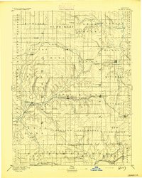 1894 Seneca1894 Print · USGSNortheastern Kansas is captured here in the late nineteenth century as a thriving rail and river corridor. You can trace early community sites like Guittard Station, Taylor Rapids, and America City along the Missouri Pacific Railroad.4 unique versions available
 - 1894 Map of Topeka
 1894 Topeka1894 Print · USGSTopeka and its northern reaches are captured here in the late nineteenth century, during a pivotal era of rail expansion and settlement. Local historians can trace the early layouts of Topeka and Silver Lake alongside the Pottawatomie Indian Reservation.5 unique versions available
 - 1894 Map of Hiawatha
 1894 Hiawatha1894 Print · USGSNortheastern Kansas was a bustling intersection of tribal lands and iron rails in the late nineteenth century. Genealogists and historians can trace the early development of Hiawatha, the boundaries of the Kickapoo Indian Reservation, and rail stops like Netawaka or Berwick.4 unique versions available
 - 1894 Map of Wamego
 1894 Wamego1894 Print · USGSThe Kansas prairie in the late nineteenth century was a world of steam and river crossings, where the iron horse reshaped the frontier. Genealogists can trace family roots in established towns like Wamego, Alma, or the small settlement of Moodyville along Rock Creek.5 unique versions available
End of results
Showing maps 1-4 of 4
Top cities of Jackson County
- Holton historical maps
- Hoyt historical maps
- Mayetta historical maps
- Denison historical maps
- Whiting historical maps
- Delia historical maps
See more
Frequently asked questions
- What are the different types of historical maps available for Jackson County?
- What is the oldest map of Jackson County?
- Where can I purchase historical maps of Jackson County for my home or office?
- Where can I download high-res historical maps of Jackson County?
- Are there historical topographic maps available for Jackson County?
- Is there historical aerial imagery available for Jackson County?
- Where are historical maps of Jackson County sourced from?