1990s Maps of Meadowridge, Olathe
Explore 2 historic maps of Meadowridge from the 1990s. These maps offer a rare glimpse into what life looked like during the 1990s — showing old roads, neighborhoods, homes, and landmarks that have changed or disappeared over time.
Whether you're researching your family's past, planning a metal detecting trip, or studying how Meadowridge's landscape evolved across the 1990s, these high-resolution maps are a powerful tool for exploring the history of this region.
- Focus on a specific era: All maps on this page are from the 1990s, giving you a focused view of this time period.
- See what’s changed: Compare century-old streets, trails, and buildings to today's modern landscape using overlays and satellite layers.
- Research with precision: Use these maps for genealogy, historical research, land use analysis, or educational projects.
- View, download, or print: Maps are fully viewable online in high resolution, and can be downloaded or printed for your own records.
Start exploring Meadowridge's history through authentic maps from the 1990s. This is your window into the past.
Meadowridge, Olathe maps
(2)- 1991 Map of Olathe, 1995 Print
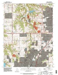 1991 Olathe1995 Print · USGSJohnson County was experiencing rapid suburban transformation during the 1990s as it grew around traditional hubs. Genealogists and historians can trace institutional sites like the State School For The Deaf and County Farm, alongside older locales like Monticello and Lackmans.
 - 1991 Map of Ocheltree, 1996 Print
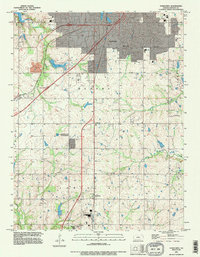 1991 Ocheltree1996 Print · USGSThe growing outskirts of Olathe and Spring Hill are captured here in the early nineties as suburban expansion began meeting the traditional rural landscape. Researchers can trace the placement of Calvary Cem, the rail-side settlement of Bonita, and water features like New Olathe Lake.
End of results
Showing maps 1-2 of 2
Frequently asked questions
- What are the different types of historical maps available for Meadowridge?
- What is the oldest map of Meadowridge?
- Where can I purchase historical maps of Meadowridge for my home or office?
- Where can I download high-res historical maps of Meadowridge?
- Are there historical topographic maps available for Meadowridge?
- Is there historical aerial imagery available for Meadowridge?
- Where are historical maps of Meadowridge sourced from?