1970s Maps of Parsons, Kansas
Explore 4 historic maps of Parsons from the 1970s. These maps offer a rare glimpse into what life looked like during the 1970s — showing old roads, neighborhoods, homes, and landmarks that have changed or disappeared over time.
Whether you're researching your family's past, planning a metal detecting trip, or studying how Parsons's landscape evolved across the 1970s, these high-resolution maps are a powerful tool for exploring the history of this region.
- Focus on a specific era: All maps on this page are from the 1970s, giving you a focused view of this time period.
- See what’s changed: Compare century-old streets, trails, and buildings to today's modern landscape using overlays and satellite layers.
- Research with precision: Use these maps for genealogy, historical research, land use analysis, or educational projects.
- View, download, or print: Maps are fully viewable online in high resolution, and can be downloaded or printed for your own records.
Start exploring Parsons's history through authentic maps from the 1970s. This is your window into the past.
Parsons, KS maps
(4)- 1973 Map of Parsons East, 1975 Print
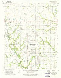 1973 Parsons East1975 Print · USGSLabette County's industrial and rural character is on full display in the early 1970s, as the massive Kansas Army Ammunition Plant operates alongside traditional prairie settlements. Researchers can trace family history through sites like Oakwood Cem and Center Bethel Ch or follow the paths of the St Louis - San Francisco railroad.
 - 1973 Map of South Mound, 1975 Print
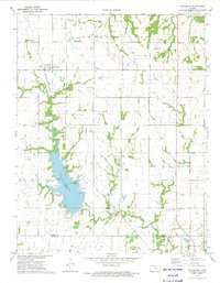
 1973 South Mound1975 Print · USGSThe Neosho River valley in the early 1970s shows a landscape of tight river bends and established rail corridors. Trace local family roots at Union Cem or explore the infrastructure of the day, from the Parsons Dam to the South Mound settlement.
 - 1973 Map of Parsons West, 1975 Print
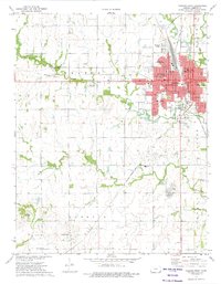 1973 Parsons West1975 Print · USGSParsons was a bustling Labette County hub in the early seventies, caught between its rail-industrial roots and its role as a regional medical and educational center. Researchers can trace family sites at Hopewell Ch, the Wilsonton Cem, or the Parsons State Hospital grounds.
 - 1973 Map of Galesburg, 1975 Print
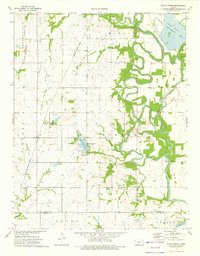
 1973 Galesburg1975 Print · USGSThe rural border of Neosho and Labette Counties is captured here in the early seventies, dominated by the railroad and the waters of Lake Parsons. Genealogists can trace local history through a high density of rural cemeteries like Mt Hope Cem and Ladore Cem.
End of results
Showing maps 1-4 of 4
Top cities near Parsons
- Cherryvale historical maps
- Erie historical maps
- Altamont historical maps
- Thayer historical maps
- Mound Valley historical maps
- Galesburg historical maps
See more
Top neighborhoods of Parsons
Frequently asked questions
- What are the different types of historical maps available for Parsons?
- What is the oldest map of Parsons?
- Where can I purchase historical maps of Parsons for my home or office?
- Where can I download high-res historical maps of Parsons?
- Are there historical topographic maps available for Parsons?
- Is there historical aerial imagery available for Parsons?
- Where are historical maps of Parsons sourced from?