1900s (20th Century) Maps of Summerfield, Kansas
Explore 10 historic maps of Summerfield from the 1900s (20th Century). These maps offer a rare glimpse into what life looked like during the 1900s — showing old roads, neighborhoods, homes, and landmarks that have changed or disappeared over time.
Whether you're researching your family's past, planning a metal detecting trip, or studying how Summerfield's landscape evolved across the 1900s, these high-resolution maps are a powerful tool for exploring the history of this region.
- Focus on a specific era: All maps on this page are from the 1900s, giving you a focused view of this time period.
- See what’s changed: Compare century-old streets, trails, and buildings to today's modern landscape using overlays and satellite layers.
- Research with precision: Use these maps for genealogy, historical research, land use analysis, or educational projects.
- View, download, or print: Maps are fully viewable online in high resolution, and can be downloaded or printed for your own records.
Start exploring Summerfield's history through authentic maps from the 1900s. This is your window into the past.
Summerfield, KS maps
(10)- 1955 Map of Manhattan, 1964 Print
 1955 Manhattan1964 Print · USGSNorth Central Kansas is captured here in the mid-fifties, just as major flood control projects began reshaping the river valleys. Genealogists can locate family sites near St. Joseph Church, Sunset Cemetery, or along the busy tracks of the Rock Island RR.4 unique versions available
 - 1955 Map of Lincoln, 1967 Print
 1955 Lincoln1967 Print · USGSSoutheast Nebraska in the mid-fifties presents a landscape of thriving railroad towns and the expanding footprint of the capital city. Researchers can trace the legacy of the pioneer era at the Homestead National Monument of America or locate mid-century military infrastructure like Lincoln Air Force Base.5 unique versions available
 - 1956 Map of Manhattan
 1956 Manhattan1956 Print · USGSNorth-central Kansas in the mid-fifties reveals a landscape defined by the convergence of the Republican River and Smoky Hill River. Historians can trace the rail corridors of the Union Pacific RR and Missouri Pacific RR through towns like Manhattan and Clay Center.
 - 1957 Map of Manhattan
 1957 Manhattan1957 Print · USGSNortheast Kansas in the mid-1950s reveals a landscape of expanding military installations and new water projects. Genealogists and historians can trace the rail-to-river economy through the Union Pacific RR and old settlements like Clay Center or Marysville.
 - 1957 Map of Lincoln
 1957 Lincoln1957 Print · USGSSoutheastern Nebraska at mid-century shows a landscape of thriving rail towns and expanding infrastructure centered on Lincoln. Researchers can trace the path of the Chicago Burlington and Quincy railroad through communities like Weeping Water, Fairmont, and Seward.
 - 1958 Map of Lincoln
 1958 Lincoln1958 Print · USGSSoutheast Nebraska at the end of the 1950s shows a region defined by agricultural trade and the expansion of the state capital. Genealogists can trace family footprints across the Blue Valley and locate landmarks like the Lincoln AFB or the U.S. Veterans Hospital.
 - 1965 Map of Liberty SE, 1966 Print
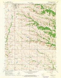
 1965 Liberty SE1966 Print · USGSCrossing the Nebraska-Kansas border in the mid-1960s, this area captures the rural character of Pawnee and Marshall counties. Genealogists and historians can trace the Old Railroad Grade and locate local landmarks like Summerfield Cem and Salem Sch.
 - 1966 Map of Summerfield, 1967 Print
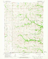
 1966 Summerfield1967 Print · USGSThe Kansas-Nebraska borderlands in Marshall County come to life in the mid-1960s, showing a landscape defined by rail lines and rural townships. Genealogists and historians can trace family plots at St Bridget Cem and Rose Hill Cem, or follow the Union Pacific tracks through Axtell.2 unique versions available
 - 1986 Map of Beatrice
 1986 Beatrice1986 Print · USGSSoutheast Nebraska and the Kansas borderlands appear in the mid-1980s as a thriving agricultural region centered on the Big Blue River. Researchers can trace historic rail routes like the Burlington Northern through hubs such as Beatrice and Pawnee City.2 unique versions available
 - 1986 Map of Blue Rapids
 1986 Blue Rapids1986 Print · USGSNortheast Kansas in the mid-eighties was a landscape of river-valley towns and steady rail lines. Researchers can trace family ties and early settlements from Hollenberg and Marysville down to the shores of Tuttle Creek Lake and the Big Blue River.2 unique versions available
End of results
Showing maps 1-10 of 10
Top cities near Summerfield
- Pawnee City historical maps
- Axtell historical maps
- Beattie historical maps
- Barneston historical maps
- Burchard historical maps
- Liberty historical maps
See more
Frequently asked questions
- What are the different types of historical maps available for Summerfield?
- What is the oldest map of Summerfield?
- Where can I purchase historical maps of Summerfield for my home or office?
- Where can I download high-res historical maps of Summerfield?
- Are there historical topographic maps available for Summerfield?
- Is there historical aerial imagery available for Summerfield?
- Where are historical maps of Summerfield sourced from?