1980s Maps of Summerfield, Kansas
Explore 2 historic maps of Summerfield from the 1980s. These maps offer a rare glimpse into what life looked like during the 1980s — showing old roads, neighborhoods, homes, and landmarks that have changed or disappeared over time.
Whether you're researching your family's past, planning a metal detecting trip, or studying how Summerfield's landscape evolved across the 1980s, these high-resolution maps are a powerful tool for exploring the history of this region.
- Focus on a specific era: All maps on this page are from the 1980s, giving you a focused view of this time period.
- See what’s changed: Compare century-old streets, trails, and buildings to today's modern landscape using overlays and satellite layers.
- Research with precision: Use these maps for genealogy, historical research, land use analysis, or educational projects.
- View, download, or print: Maps are fully viewable online in high resolution, and can be downloaded or printed for your own records.
Start exploring Summerfield's history through authentic maps from the 1980s. This is your window into the past.
Summerfield, KS maps
(2)- 1986 Map of Beatrice
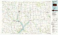
 1986 Beatrice1986 Print · USGSSoutheast Nebraska and the Kansas borderlands appear in the mid-1980s as a thriving agricultural region centered on the Big Blue River. Researchers can trace historic rail routes like the Burlington Northern through hubs such as Beatrice and Pawnee City.2 unique versions available
 - 1986 Map of Blue Rapids
 1986 Blue Rapids1986 Print · USGSNortheast Kansas in the mid-eighties was a landscape of river-valley towns and steady rail lines. Researchers can trace family ties and early settlements from Hollenberg and Marysville down to the shores of Tuttle Creek Lake and the Big Blue River.2 unique versions available
End of results
Showing maps 1-2 of 2
Top cities near Summerfield
- Pawnee City historical maps
- Axtell historical maps
- Beattie historical maps
- Barneston historical maps
- Burchard historical maps
- Liberty historical maps
See more
Frequently asked questions
- What are the different types of historical maps available for Summerfield?
- What is the oldest map of Summerfield?
- Where can I purchase historical maps of Summerfield for my home or office?
- Where can I download high-res historical maps of Summerfield?
- Are there historical topographic maps available for Summerfield?
- Is there historical aerial imagery available for Summerfield?
- Where are historical maps of Summerfield sourced from?