1970s Maps of Helmick, Kansas
Explore 1 historic maps of Helmick from the 1970s. These maps offer a rare glimpse into what life looked like during the 1970s — showing old roads, neighborhoods, homes, and landmarks that have changed or disappeared over time.
Whether you're researching your family's past, planning a metal detecting trip, or studying how Helmick's landscape evolved across the 1970s, these high-resolution maps are a powerful tool for exploring the history of this region.
- Focus on a specific era: All maps on this page are from the 1970s, giving you a focused view of this time period.
- See what’s changed: Compare century-old streets, trails, and buildings to today's modern landscape using overlays and satellite layers.
- Research with precision: Use these maps for genealogy, historical research, land use analysis, or educational projects.
- View, download, or print: Maps are fully viewable online in high resolution, and can be downloaded or printed for your own records.
Start exploring Helmick's history through authentic maps from the 1970s. This is your window into the past.
Helmick, KS maps
(1)- 1971 Map of Council Grove Lake, 1974 Print
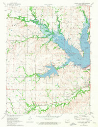 1971 Council Grove Lake1974 Print · USGSMorris County was undergoing a major hydrological shift in the early 1970s as the Neosho River valley was reshaped by flood control projects. Researchers can trace the Old Indian Treaty Boundary and locate family history sites like Kelso Cem and Greenwood Cemetery.
End of results
Showing maps 1-1 of 1
Top cities near Helmick
- Council Grove historical maps
- Strong City historical maps
- White City historical maps
- Dwight historical maps
- Wilsey historical maps
- Parkerville historical maps
Frequently asked questions
- What are the different types of historical maps available for Helmick?
- What is the oldest map of Helmick?
- Where can I purchase historical maps of Helmick for my home or office?
- Where can I download high-res historical maps of Helmick?
- Are there historical topographic maps available for Helmick?
- Is there historical aerial imagery available for Helmick?
- Where are historical maps of Helmick sourced from?