1980s Maps of Norton County, Kansas
Explore 3 historic maps of Norton County from the 1980s. These maps offer a rare glimpse into what life looked like during the 1980s — showing old roads, neighborhoods, homes, and landmarks that have changed or disappeared over time.
Whether you're researching your family's past, planning a metal detecting trip, or studying how Norton County's landscape evolved across the 1980s, these high-resolution maps are a powerful tool for exploring the history of this region.
- Focus on a specific era: All maps on this page are from the 1980s, giving you a focused view of this time period.
- See what’s changed: Compare century-old streets, trails, and buildings to today's modern landscape using overlays and satellite layers.
- Research with precision: Use these maps for genealogy, historical research, land use analysis, or educational projects.
- View, download, or print: Maps are fully viewable online in high resolution, and can be downloaded or printed for your own records.
Start exploring Norton County's history through authentic maps from the 1980s. This is your window into the past.
Norton County, KS maps
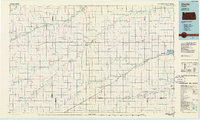
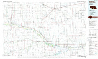
(3)- 1985 Map of Norton
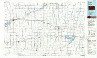 1985 Norton1985 Print · USGSNorth-central Kansas in the mid-1980s reveals a landscape of prairie commerce and water conservation across Norton and Phillips Counties. Researchers can trace the Burlington Northern Railroad and find local landmarks like Fairview Cemetery and the Kirwin National Wildlife Refuge.2 unique versions available
 - 1985 Map of Oberlin
 1985 Oberlin1985 Print · USGSNorthwest Kansas in the mid-eighties was a landscape of resilient prairie towns and winding creek drainages. Researchers can trace the Burlington Northern rail corridor through Jennings and Selden or locate local landmarks like the Municipal Airport and Keith Sebelius Lake.2 unique versions available
 - 1986 Map of Holdrege
 1986 Holdrege1986 Print · USGSSouthern Nebraska and the Kansas borderlands appear here in the mid-eighties as a region defined by river valleys and rail-connected agricultural hubs. Trace local history through settlements like Republican City, the Prairie Home Cem, and the waters of Harlan County Lake.2 unique versions available
End of results
Showing maps 1-3 of 3
Top cities of Norton County
Frequently asked questions
- What are the different types of historical maps available for Norton County?
- What is the oldest map of Norton County?
- Where can I purchase historical maps of Norton County for my home or office?
- Where can I download high-res historical maps of Norton County?
- Are there historical topographic maps available for Norton County?
- Is there historical aerial imagery available for Norton County?
- Where are historical maps of Norton County sourced from?