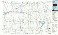
1985 Map of Norton
USGS Topo · Published 1985About this map
Keith Sebelius Lake and the surrounding Prairie Dog State Park dominate the western portion of this 1985 survey, illustrating the significant water management and recreation infrastructure of north-central Kansas. The Burlington Northern Railroad cuts a diagonal path through the landscape, connecting settlements like Almena, Long Island, and the regional hub of Norton. This transport corridor parallels Prairie Dog Creek, showing how historical transit routes were influenced by the natural drainage of the High Plains.
Find a feature on this map
83 named features on this map. Tap any name to fly to it.
Don’t see what you’re looking for? This feature index may not catch every label — zoom into the map to look around manually.
Map Details
Editions of this 1985 Norton Map
2 editions found
Other maps of this area

1893 · Smith Center
USGS Topo · 1:125,000

1893 · Norton
USGS Topo · 1:125,000

1893 · Phillipsburg
USGS Topo · 1:125,000

1893 · Hill
USGS Topo · 1:125,000

1896 · Holdrege
USGS Topo · 1:125,000

1896 · Osborne
USGS Topo · 1:125,000

1896 · Arapahoe
USGS Topo · 1:125,000

1896 · Plainville
USGS Topo · 1:125,000

1897 · Red Cloud
USGS Topo · 1:125,000

1898 · Arapahoe
USGS Topo · 1:125,000