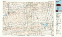
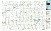
1985 Map of Norton
USGS Topo · Published 1990About this map
Norton and Phillipsburg serve as the primary hubs in this mid-1980s look at Northwest Kansas, a landscape defined by the drainage basins of the North Fork Solomon River and Prairie Dog Creek. The region's commitment to land and water management is evident in the sprawling Kirwin National Wildlife Refuge and the Kirwin Reservoir, alongside Keith Sebelius Lake and the adjacent Prairie Dog State Park. This period shows the transition of rail infrastructure with the Kyle RR serving the agricultural corridor that connects smaller communities like Almena, Prairie View, and Agra.
Find a feature on this map
80 named features on this map. Tap any name to fly to it.
Don’t see what you’re looking for? This feature index may not catch every label — zoom into the map to look around manually.
Map Details
Editions of this 1985 Norton Map
2 editions found
Other maps of this area

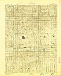
1893 · Smith Center
USGS Topo · 1:125,000

1893 · Norton
USGS Topo · 1:125,000
1893 · Phillipsburg
USGS Topo · 1:125,000

1893 · Hill
USGS Topo · 1:125,000

1896 · Holdrege
USGS Topo · 1:125,000

1896 · Osborne
USGS Topo · 1:125,000

1896 · Arapahoe
USGS Topo · 1:125,000

1896 · Plainville
USGS Topo · 1:125,000

1897 · Red Cloud
USGS Topo · 1:125,000

1898 · Arapahoe
USGS Topo · 1:125,000