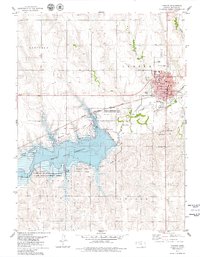
1978 Map of Norton
USGS Topo · Published 1979About this map
Norton Reservoir dominates the western portion of this landscape, its complex shoreline defined by the flooded valley of Prairie Dog Creek. By the late 1970s, the area surrounding the water had developed into a recreation and conservation hub, featuring the Prairie Dog State Park and the extensive Norton Reservoir State Game Management Area. The city of Norton serves as the regional center to the northeast, showing a dense street grid organized around the local Courthouse and the Chicago Rock Island and Northern Pacific railroad line.
Find a feature on this map
29 named features on this map. Tap any name to fly to it.
Don’t see what you’re looking for? This feature index may not catch every label — zoom into the map to look around manually.
Map Details
Editions of this 1978 Norton Map
This is the sole edition of this map. No revisions or reprints were ever made.
Other maps of this area

1893 · Norton
USGS Topo · 1:125,000

1951 · Norton
USGS Topo · 1:62,500

1951 · Norcatur
USGS Topo · 1:62,500

1954 · Goodland
USGS Topo · 1:250,000

1955 · Beloit
USGS Topo · 1:250,000

1956 · Goodland
USGS Topo · 1:250,000

1957 · Goodland
USGS Topo · 1:250,000

1959 · Beloit
USGS Topo · 1:250,000
1965 · Norton NW
USGS Topo · 1:24,000
1965 · Devizes
USGS Topo · 1:24,000