
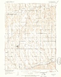
1951 Map of Norcatur
USGS Topo · Published 1952About this map
Norcatur sits as the primary rail hub on this High Plains landscape, where the Chicago Burlington and Quincy railroad cuts a diagonal line toward the smaller community of Reager. Further south, the Chicago Rock Island and Pacific runs through the valley of Prairie Dog Creek, connecting the settlements of Oronoque and Dellvale. The map reveals a highly structured rural society defined by its township boundaries, such as Lincoln and Garfield, and an extensive network of country schools that once served these agrarian townships. Educational landmarks like Lone Hand Sch, Rose Hill Sch, and Prairie Belle Sch are scattered across the terrain, often appearing miles from any named town. Genealogists will find numerous family and community burial grounds, including the Hudson Pillar Cem and Wray Cem, which reflect the early settlement patterns along the branches of Sappa Creek.
Find a feature on this map
47 named features on this map. Tap any name to fly to it.
Don’t see what you’re looking for? This feature index may not catch every label — zoom into the map to look around manually.
Map Details
Editions of this 1951 Norcatur Map
2 editions found
Other maps of this area

1893 · Norton
USGS Topo · 1:125,000

1896 · Arapahoe
USGS Topo · 1:125,000

1898 · Arapahoe
USGS Topo · 1:125,000

1951 · Norton
USGS Topo · 1:62,500

1951 · Kanona
USGS Topo · 1:62,500

1954 · McCook
USGS Topo · 1:250,000

1954 · Goodland
USGS Topo · 1:250,000

1955 · Grand Island
USGS Topo · 1:250,000

1955 · Beloit
USGS Topo · 1:250,000

1956 · Goodland
USGS Topo · 1:250,000