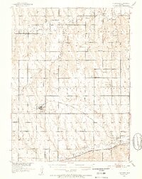
1951 Map of Norcatur
USGS Topo · Published 1952About this map
The town of Norcatur serves as a focal point in this 1951 survey, situated along the Chicago Burlington And Quincy railroad line. This Kansas landscape is characterized by its organized grid of townships such as Lincoln and Garfield, interspersed with the drainage basins of Sappa Creek and Prairie Dog Creek. The distribution of one-room schoolhouses like Lone Hand Sch, Spring Branch Sch, and Rose Hill Sch reveals the rural community structure of Decatur and Norton Counties during the early postwar period.
Find a feature on this map
48 named features on this map. Tap any name to fly to it.
Don’t see what you’re looking for? This feature index may not catch every label — zoom into the map to look around manually.
Map Details
Editions of this 1951 Norcatur Map
2 editions found
Other maps of this area

1893 · Norton
USGS Topo · 1:125,000

1896 · Arapahoe
USGS Topo · 1:125,000

1898 · Arapahoe
USGS Topo · 1:125,000

1951 · Norton
USGS Topo · 1:62,500

1951 · Norcatur
USGS Topo · 1:62,500

1951 · Kanona
USGS Topo · 1:62,500

1954 · McCook
USGS Topo · 1:250,000

1954 · Goodland
USGS Topo · 1:250,000

1955 · Grand Island
USGS Topo · 1:250,000

1955 · Beloit
USGS Topo · 1:250,000