1900s (20th Century) Maps of Kirwin, Kansas
Explore 5 historic maps of Kirwin from the 1900s (20th Century). These maps offer a rare glimpse into what life looked like during the 1900s — showing old roads, neighborhoods, homes, and landmarks that have changed or disappeared over time.
Whether you're researching your family's past, planning a metal detecting trip, or studying how Kirwin's landscape evolved across the 1900s, these high-resolution maps are a powerful tool for exploring the history of this region.
- Focus on a specific era: All maps on this page are from the 1900s, giving you a focused view of this time period.
- See what’s changed: Compare century-old streets, trails, and buildings to today's modern landscape using overlays and satellite layers.
- Research with precision: Use these maps for genealogy, historical research, land use analysis, or educational projects.
- View, download, or print: Maps are fully viewable online in high resolution, and can be downloaded or printed for your own records.
Start exploring Kirwin's history through authentic maps from the 1900s. This is your window into the past.
Kirwin, KS maps
(5)- 1955 Map of Beloit, 1971 Print
 1955 Beloit1971 Print · USGSNorth Central Kansas in the mid-fifties shows a landscape of river-valley agriculture and expanding water infrastructure. Genealogists can trace the rail lines of the Union Pacific through towns like Nicodemus, Cawker City, and the State Sanatorium.3 unique versions available
 - 1959 Map of Beloit
 1959 Beloit1959 Print · USGSNorth Central Kansas at mid-century reveals a landscape shaped by river valleys and the expansion of massive water reservoirs. Genealogists and historians can trace the rail-town connections of Beloit and Norton or locate the site of the new Webster Dam.3 unique versions available
 - 1972 Map of Kirwin, 1974 Print
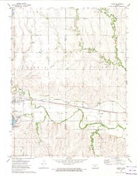 1972 Kirwin1974 Print · USGSThe North Fork Solomon River valley in the early 1970s shows a landscape transformed by the Kirwin Dam. Researchers can trace the Missouri Pacific rail line through Kirwin and Claudell or locate the Olive Branch Cem near the reservoir.
 - 1972 Map of Kirwin Reservoir, 1974 Print
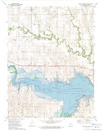 1972 Kirwin Reservoir1974 Print · USGSPhillips County in the early seventies shows a landscape reshaped by the Kirwin Reservoir and its surrounding wildlife refuge. Genealogists and researchers can trace local history through Kirwin Cem, the Missouri Pacific railroad, and the Old Railroad Grade.
 - 1985 Map of Norton
 1985 Norton1985 Print · USGSNorth-central Kansas in the mid-1980s reveals a landscape of prairie commerce and water conservation across Norton and Phillips Counties. Researchers can trace the Burlington Northern Railroad and find local landmarks like Fairview Cemetery and the Kirwin National Wildlife Refuge.2 unique versions available
End of results
Showing maps 1-5 of 5
Top cities near Kirwin
- Phillipsburg historical maps
- Stockton historical maps
- Kensington historical maps
- Agra historical maps
- Woodston historical maps
- Alton historical maps
See more
Frequently asked questions
- What are the different types of historical maps available for Kirwin?
- What is the oldest map of Kirwin?
- Where can I purchase historical maps of Kirwin for my home or office?
- Where can I download high-res historical maps of Kirwin?
- Are there historical topographic maps available for Kirwin?
- Is there historical aerial imagery available for Kirwin?
- Where are historical maps of Kirwin sourced from?