1970s Maps of Phillipsburg, Kansas
Explore 2 historic maps of Phillipsburg from the 1970s. These maps offer a rare glimpse into what life looked like during the 1970s — showing old roads, neighborhoods, homes, and landmarks that have changed or disappeared over time.
Whether you're researching your family's past, planning a metal detecting trip, or studying how Phillipsburg's landscape evolved across the 1970s, these high-resolution maps are a powerful tool for exploring the history of this region.
- Focus on a specific era: All maps on this page are from the 1970s, giving you a focused view of this time period.
- See what’s changed: Compare century-old streets, trails, and buildings to today's modern landscape using overlays and satellite layers.
- Research with precision: Use these maps for genealogy, historical research, land use analysis, or educational projects.
- View, download, or print: Maps are fully viewable online in high resolution, and can be downloaded or printed for your own records.
Start exploring Phillipsburg's history through authentic maps from the 1970s. This is your window into the past.
Phillipsburg, KS maps
(2)- 1972 Map of Phillipsburg South, 1974 Print
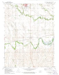 1972 Phillipsburg South1974 Print · USGSPhillips County in the early seventies shows a landscape shaped by the Solomon River and the Missouri Pacific rail line. Researchers can trace the layout of Phillipsburg and Glade, or locate specific landmarks like Fairview Cemetery, the Drive-in Theater, and the Kirwin Reservoir.
 - 1973 Map of Phillipsburg North, 1975 Print
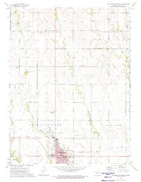 1973 Phillipsburg North1975 Print · USGSPhillipsburg and the surrounding North-Central Kansas prairies are captured in the early seventies, showing a period of industrial activity and established civic life. Genealogists and local historians can locate the Iowa Union Cem, trace the Chicago Rock Island and Pacific rail line, and find the town Courthouse.
End of results
Showing maps 1-2 of 2
Top cities near Phillipsburg
- Agra historical maps
- Kirwin historical maps
- Long Island historical maps
- Glade historical maps
- Speed historical maps
Frequently asked questions
- What are the different types of historical maps available for Phillipsburg?
- What is the oldest map of Phillipsburg?
- Where can I purchase historical maps of Phillipsburg for my home or office?
- Where can I download high-res historical maps of Phillipsburg?
- Are there historical topographic maps available for Phillipsburg?
- Is there historical aerial imagery available for Phillipsburg?
- Where are historical maps of Phillipsburg sourced from?