1900s (20th Century) Maps of Salina, Kansas
Explore 8 historic maps of Salina from the 1900s (20th Century). These maps offer a rare glimpse into what life looked like during the 1900s — showing old roads, neighborhoods, homes, and landmarks that have changed or disappeared over time.
Whether you're researching your family's past, planning a metal detecting trip, or studying how Salina's landscape evolved across the 1900s, these high-resolution maps are a powerful tool for exploring the history of this region.
- Focus on a specific era: All maps on this page are from the 1900s, giving you a focused view of this time period.
- See what’s changed: Compare century-old streets, trails, and buildings to today's modern landscape using overlays and satellite layers.
- Research with precision: Use these maps for genealogy, historical research, land use analysis, or educational projects.
- View, download, or print: Maps are fully viewable online in high resolution, and can be downloaded or printed for your own records.
Start exploring Salina's history through authentic maps from the 1900s. This is your window into the past.
Salina, KS maps
(8)- 1942 Map of Salina
 1942 Salina1942 Print · USGSCentral Kansas during the early 1940s reveals a landscape transitioning between its deep agricultural roots and a massive new wartime footing. Researchers can trace the development of the Military Reservation and locate small rail-side settlements like Terra Cotta and Smolan.
 - 1955 Map of Salina, 1956 Print
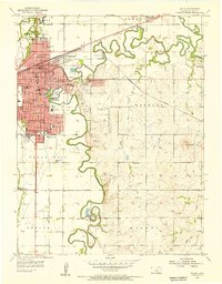 1955 Salina1956 Print · USGSMid-century Salina is captured here as a bustling educational and military hub at the height of the Cold War. Genealogists and local historians can trace neighborhood growth through numerous local schools like Hawthorne Sch and locate ancestors at Mt Calvary Cem or Memorial Park Cemetery.2 unique versions available
 - 1955 Map of Salina SW, 1956 Print
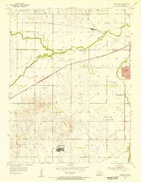 1955 Salina SW1956 Print · USGSThe outskirts of Salina are captured here in the mid-fifties during a period of significant military and suburban expansion. Researchers can trace the development of Phillips Village, the grounds of the Smoky Hill Air Force Base, and local landmarks like St Francis Boys Home.3 unique versions available
 - 1955 Map of New Cambria, 1956 Print
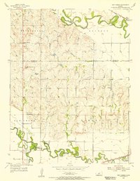 1955 New Cambria1956 Print · USGSThe confluence of the Solomon and Saline rivers defines this Kansas landscape in the mid-fifties, just as the local rail and radio infrastructure was maturing. Researchers can trace rural landmarks like the Saline Valley Gem Humbargar Sch, Highland Cem, and North Pole Mound.2 unique versions available
 - 1955 Map of Hutchinson, 1967 Print
 1955 Hutchinson1967 Print · USGSCentral Kansas in the mid-sixties reveals a landscape of growing reservoirs and evolving transportation corridors. Trace the development of towns like Hutchinson and Abilene alongside the Union Pacific Railroad and the expanding Interstate 70.3 unique versions available
 - 1959 Map of Hutchinson
 1959 Hutchinson1959 Print · USGSCentral Kansas thrives at the intersection of rail and river in the mid-1950s, as post-war aviation infrastructure reshapes the prairie. Genealogists and historians can trace the paths of the AT&SF RR through Newton and Hutchinson, or locate military sites like Smoky Hill Air Force Base.2 unique versions available
 - 1985 Map of Salina
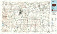
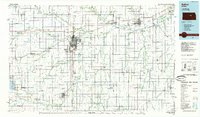 1985 Salina1985 Print · USGSCentral Kansas in the mid-1980s reveals a landscape defined by river confluences and a dense rail network. Genealogists and historians can trace established communities like Salina and Lindsborg, alongside landmarks like Bethany College and Kanopolis Lake.
 - 1990 Map of Salina
 1990 Salina1990 Print · USGSThe Smoky Hill River valley thrived in the late twentieth century as a vital crossroads of Kansas industry and education. Genealogists can trace family roots through the detailed plots of Elmwood Cem and Mt Calvary Cem or locate the historic campus of Bethany College.
End of results
Showing maps 1-8 of 8
Top cities near Salina
- Bennington historical maps
- Assaria historical maps
- Gypsum historical maps
- Falun historical maps
- Brookville historical maps
- Smolan historical maps
See more
Frequently asked questions
- What are the different types of historical maps available for Salina?
- What is the oldest map of Salina?
- Where can I purchase historical maps of Salina for my home or office?
- Where can I download high-res historical maps of Salina?
- Are there historical topographic maps available for Salina?
- Is there historical aerial imagery available for Salina?
- Where are historical maps of Salina sourced from?