1940s Maps of Tolerville, Bel Aire
Explore 2 historic maps of Tolerville from the 1940s. These maps offer a rare glimpse into what life looked like during the 1940s — showing old roads, neighborhoods, homes, and landmarks that have changed or disappeared over time.
Whether you're researching your family's past, planning a metal detecting trip, or studying how Tolerville's landscape evolved across the 1940s, these high-resolution maps are a powerful tool for exploring the history of this region.
- Focus on a specific era: All maps on this page are from the 1940s, giving you a focused view of this time period.
- See what’s changed: Compare century-old streets, trails, and buildings to today's modern landscape using overlays and satellite layers.
- Research with precision: Use these maps for genealogy, historical research, land use analysis, or educational projects.
- View, download, or print: Maps are fully viewable online in high resolution, and can be downloaded or printed for your own records.
Start exploring Tolerville's history through authentic maps from the 1940s. This is your window into the past.
Tolerville, Bel Aire maps
(2)- 1941 Map of Valley Center
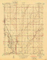 1941 Valley Center1941 Print · USGSSedgwick County agricultural lands and growing townships are captured here at the start of the 1940s. Local historians can trace the foundations of Valley Center and Keehi alongside vanished landmarks like the Stearns Race Track and Hoss Sch.
 - 1942 Map of Valley Center
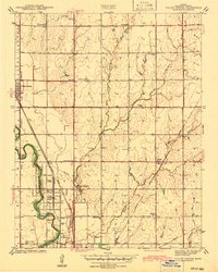 1942 Valley Center1942 Print · USGSNorth of Wichita just before the war, this area shows a landscape defined by the Little Arkansas River and a busy intersection of four major railroads. Genealogists can locate numerous country schoolhouses like Riverview Sch and Hillside Grove Sch, as well as the MARBLE GROVE CEM and the old STEARNS RACE TRACK.
End of results
Showing maps 1-2 of 2
Top cities near Tolerville
- Wichita historical maps
- Derby historical maps
- Haysville historical maps
- Andover historical maps
- Augusta historical maps
- Park City historical maps
See more
Frequently asked questions
- What are the different types of historical maps available for Tolerville?
- What is the oldest map of Tolerville?
- Where can I purchase historical maps of Tolerville for my home or office?
- Where can I download high-res historical maps of Tolerville?
- Are there historical topographic maps available for Tolerville?
- Is there historical aerial imagery available for Tolerville?
- Where are historical maps of Tolerville sourced from?