1940s Maps of Ohio Township, Kansas
Explore 2 historic maps of Ohio Township from the 1940s. These maps offer a rare glimpse into what life looked like during the 1940s — showing old roads, neighborhoods, homes, and landmarks that have changed or disappeared over time.
Whether you're researching your family's past, planning a metal detecting trip, or studying how Ohio Township's landscape evolved across the 1940s, these high-resolution maps are a powerful tool for exploring the history of this region.
- Focus on a specific era: All maps on this page are from the 1940s, giving you a focused view of this time period.
- See what’s changed: Compare century-old streets, trails, and buildings to today's modern landscape using overlays and satellite layers.
- Research with precision: Use these maps for genealogy, historical research, land use analysis, or educational projects.
- View, download, or print: Maps are fully viewable online in high resolution, and can be downloaded or printed for your own records.
Start exploring Ohio Township's history through authentic maps from the 1940s. This is your window into the past.
Ohio Township, KS maps
(2)- 1943 Map of Derby
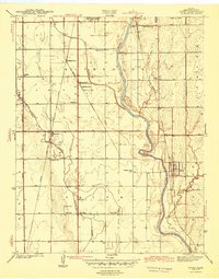 1943 Derby1943 Print · USGSSouthern Sedgwick County in the early 1940s is a landscape of river-valley farms and essential rail corridors just before the region's rapid growth. Researchers can locate original sites for Old Waco, Derby, and numerous rural schools like Blood Sch.2 unique versions available
 - 1943 Map of Bayneville
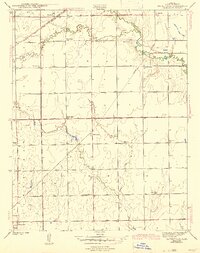 1943 Bayneville1943 Print · USGSSedgwick County farming townships are caught here in the early 1940s, showing a landscape defined by crossing rail lines and small-town junctions. Genealogists can trace family roots through numerous local schools like Richmond Hill Sch and Pleasant Plains Sch, or the rural community around Bayneville.3 unique versions available
End of results
Showing maps 1-2 of 2
Top cities near Ohio Township
- Wichita historical maps
- Derby historical maps
- Haysville historical maps
- Wellington historical maps
- Mulvane historical maps
- Minneha historical maps
See more
Top neighborhoods of Ohio Township
Frequently asked questions
- What are the different types of historical maps available for Ohio Township?
- What is the oldest map of Ohio Township?
- Where can I purchase historical maps of Ohio Township for my home or office?
- Where can I download high-res historical maps of Ohio Township?
- Are there historical topographic maps available for Ohio Township?
- Is there historical aerial imagery available for Ohio Township?
- Where are historical maps of Ohio Township sourced from?