1900s (20th Century) Maps of St. John, Kansas
Explore 11 historic maps of St. John from the 1900s (20th Century). These maps offer a rare glimpse into what life looked like during the 1900s — showing old roads, neighborhoods, homes, and landmarks that have changed or disappeared over time.
Whether you're researching your family's past, planning a metal detecting trip, or studying how St. John's landscape evolved across the 1900s, these high-resolution maps are a powerful tool for exploring the history of this region.
- Focus on a specific era: All maps on this page are from the 1900s, giving you a focused view of this time period.
- See what’s changed: Compare century-old streets, trails, and buildings to today's modern landscape using overlays and satellite layers.
- Research with precision: Use these maps for genealogy, historical research, land use analysis, or educational projects.
- View, download, or print: Maps are fully viewable online in high resolution, and can be downloaded or printed for your own records.
Start exploring St. John's history through authentic maps from the 1900s. This is your window into the past.
St. John, KS maps
(11)- 1955 Map of Great Bend, 1966 Print
 1955 Great Bend1966 Print · USGSCentral Kansas during the mid-sixties transition reveals a landscape defined by new reservoirs and enduring rail corridors. Researchers can trace the development of towns like Hays and Great Bend or locate natural landmarks such as Round Mound and the wetlands of the Quivira National Wildlife Refuge.3 unique versions available
 - 1955 Map of Pratt, 1968 Print
 1955 Pratt1968 Print · USGSSouth-central Kansas during the mid-fifties presents a landscape of sprawling oil fields and critical rail junctions. Researchers can trace the paths of the Atchison Topeka and Santa Fe railroad or locate local landmarks like the Blue Ridge Community House and Camp Carlisle.3 unique versions available
 - 1957 Map of Great Bend
 1957 Great Bend1957 Print · USGSCentral Kansas at the peak of the postwar era shows a landscape of growing rail hubs and massive new water projects. Trace the routes of the Union Pacific through Hays or locate the newly formed shorelines of Cedar Bluff Reservoir and Kanopolis Reservoir.
 - 1958 Map of Great Bend
 1958 Great Bend1958 Print · USGSCentral Kansas in the late fifties reveals a landscape of high-plains agriculture and vital river crossings. Researchers can trace the development of regional hubs like Hays and Russell, or locate historic sites such as Fort Larned and the Cheyenne Bottoms wildlife area.2 unique versions available
 - 1959 Map of Pratt
 1959 Pratt1959 Print · USGSSouth-central Kansas thrived as a rail and agricultural hub in the late fifties, where the Arkansas River meets a vast grid of section roads. Researchers can trace the path of the Missouri Pacific railroad through settlements like Turon and Stafford, or locate family landmarks like the Prairie Oak School.2 unique versions available
 - 1971 Map of Hudson, 1972 Print
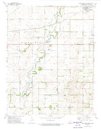
 1971 Hudson1972 Print · USGSStafford County agriculture and industry meet in the early seventies as the Missouri Pacific railroad services the grain and oil country. Genealogists and historians can trace local landmarks like New Hope Ch and follow Rattlesnake Creek through the townships of Hayes and West Cooper.
 - 1972 Map of Saint John North, 1974 Print
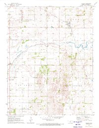
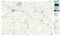
 1972 Saint John North1974 Print · USGSIn the early 1970s, the area north of Saint John was a landscape defined by the prairie petroleum industry and the winding waters of Rattlesnake Creek. Researchers can locate rural landmarks like the Eden Valley Ch, the Schulz Landing Strip, and numerous Oil Wells.
 - 1972 Map of Saint John South, 1974 Print
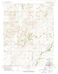
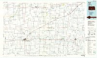
 1972 Saint John South1974 Print · USGSStafford County is captured in the early seventies during a period of agricultural stability and oil production south of Saint John. Genealogists and researchers can locate the Martin Cem, trace the Atchison Topeka and Santa Fe rail line, and map the Rattlesnake SE Oil Field.
 - 1972 Map of Stafford NW, 1974 Print
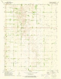 1972 Stafford NW1974 Print · USGSStafford County, Kansas, is captured in the early 1970s as a landscape shaped by petroleum and the Atchison Topeka and Santa Fe railroad. Genealogists and historians can trace local landmarks like Verning Cem, Leesburg Cem, and the Prairie Chapel.
 - 1985 Map of Great Bend
 1985 Great Bend1985 Print · USGSBarton and Rice counties come into focus during the mid-eighties as centers of rail transport and energy production. Genealogists and historians can trace the paths of the Atchison Topeka and Santa Fe through settlements like Ellinwood, Sterling, and Pawnee Rock.2 unique versions available
 - 1985 Map of Pratt
 1985 Pratt1985 Print · USGSMid-1980s South Central Kansas is captured here as a landscape of rail-connected farming towns and energy fields. Researchers can trace the Old Indian Treaty Boundary or locate local landmarks like Walnut Hill Cemetery and the State Fish Hatchery.2 unique versions available
End of results
Showing maps 1-11 of 11
Top cities near St. John
- Stafford historical maps
- Macksville historical maps
- Hudson historical maps
- Seward historical maps
- Byers historical maps
- Radium historical maps
Frequently asked questions
- What are the different types of historical maps available for St. John?
- What is the oldest map of St. John?
- Where can I purchase historical maps of St. John for my home or office?
- Where can I download high-res historical maps of St. John?
- Are there historical topographic maps available for St. John?
- Is there historical aerial imagery available for St. John?
- Where are historical maps of St. John sourced from?