1960s Maps of Stevens County, Kansas
Explore 4 historic maps of Stevens County from the 1960s. These maps offer a rare glimpse into what life looked like during the 1960s — showing old roads, neighborhoods, homes, and landmarks that have changed or disappeared over time.
Whether you're researching your family's past, planning a metal detecting trip, or studying how Stevens County's landscape evolved across the 1960s, these high-resolution maps are a powerful tool for exploring the history of this region.
- Focus on a specific era: All maps on this page are from the 1960s, giving you a focused view of this time period.
- See what’s changed: Compare century-old streets, trails, and buildings to today's modern landscape using overlays and satellite layers.
- Research with precision: Use these maps for genealogy, historical research, land use analysis, or educational projects.
- View, download, or print: Maps are fully viewable online in high resolution, and can be downloaded or printed for your own records.
Start exploring Stevens County's history through authentic maps from the 1960s. This is your window into the past.
Stevens County, KS maps
(4)- 1967 Map of Straight, 1968 Print
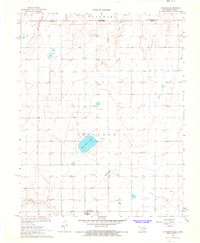 1967 Straight1968 Print · USGSThe Oklahoma-Kansas borderlands come into focus in the late 1960s, showing a landscape defined by the high plains energy industry. Genealogists and historians can locate the small settlement of Straight, the nearby Straight Landing Field, and Wild Horse Lake.
 - 1967 Map of Straight NE, 1968 Print
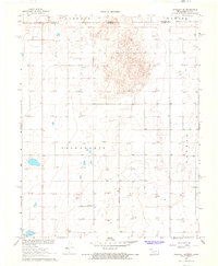 1967 Straight NE1968 Print · USGSThe Oklahoma Panhandle and Kansas border come alive in the late sixties as the energy economy transforms the agricultural plains. Genealogists and researchers can locate the Prairie Rose Community Center and trace the development of township lands in Friendship and Banner.
 - 1967 Map of Hooker NW, 1968 Print
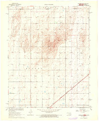 1967 Hooker NW1968 Print · USGSThe Oklahoma and Kansas borderlands are defined by energy production and heavy rail in the late sixties. Genealogists and industrial historians can trace the paths of the Chicago Rock Island and Pacific railroad and find dozens of active Gas Wells across Hooker.
 - 1967 Map of Tyrone, 1968 Print
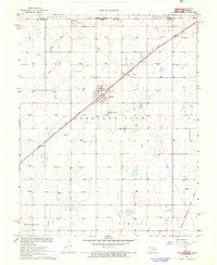 1967 Tyrone1968 Print · USGSTexas County, Oklahoma, was a landscape defined by the railroad and the oil field during the late sixties. Genealogists and local historians can trace the grid of section lines near Tyrone, locating the Tyrone Cem and the industrial hub at Fluor.2 unique versions available
End of results
Showing maps 1-4 of 4
Top cities of Stevens County
Frequently asked questions
- What are the different types of historical maps available for Stevens County?
- What is the oldest map of Stevens County?
- Where can I purchase historical maps of Stevens County for my home or office?
- Where can I download high-res historical maps of Stevens County?
- Are there historical topographic maps available for Stevens County?
- Is there historical aerial imagery available for Stevens County?
- Where are historical maps of Stevens County sourced from?