1960s Maps of Brewster, Kansas
Explore 2 historic maps of Brewster from the 1960s. These maps offer a rare glimpse into what life looked like during the 1960s — showing old roads, neighborhoods, homes, and landmarks that have changed or disappeared over time.
Whether you're researching your family's past, planning a metal detecting trip, or studying how Brewster's landscape evolved across the 1960s, these high-resolution maps are a powerful tool for exploring the history of this region.
- Focus on a specific era: All maps on this page are from the 1960s, giving you a focused view of this time period.
- See what’s changed: Compare century-old streets, trails, and buildings to today's modern landscape using overlays and satellite layers.
- Research with precision: Use these maps for genealogy, historical research, land use analysis, or educational projects.
- View, download, or print: Maps are fully viewable online in high resolution, and can be downloaded or printed for your own records.
Start exploring Brewster's history through authentic maps from the 1960s. This is your window into the past.
Brewster, KS maps
(2)- 1966 Map of Brewster, 1968 Print
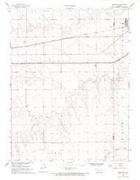 1966 Brewster1968 Print · USGSBrewster sits at the junction of rail and road during a period of high-plains modernization in the mid-sixties. Genealogists can locate Fairview Cem and trace the original path of the Chicago Rock Island and Pacific railroad.2 unique versions available
 - 1966 Map of Brewster SE, 1968 Print
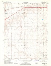 1966 Brewster SE1968 Print · USGSThomas County at the height of the mid-century highway boom reveals the transformation of the High Plains as Interstate 70 was still UNDER CONSTRUCTION. Researchers can trace the path of the CHICAGO ROCK ISLAND AND PACIFIC railroad and locate local landmarks like HUTTON AIRPORT.
End of results
Showing maps 1-2 of 2
Frequently asked questions
- What are the different types of historical maps available for Brewster?
- What is the oldest map of Brewster?
- Where can I purchase historical maps of Brewster for my home or office?
- Where can I download high-res historical maps of Brewster?
- Are there historical topographic maps available for Brewster?
- Is there historical aerial imagery available for Brewster?
- Where are historical maps of Brewster sourced from?