1930s Maps of Wyandotte County, Kansas
Explore 6 historic maps of Wyandotte County from the 1930s. These maps offer a rare glimpse into what life looked like during the 1930s — showing old roads, neighborhoods, homes, and landmarks that have changed or disappeared over time.
Whether you're researching your family's past, planning a metal detecting trip, or studying how Wyandotte County's landscape evolved across the 1930s, these high-resolution maps are a powerful tool for exploring the history of this region.
- Focus on a specific era: All maps on this page are from the 1930s, giving you a focused view of this time period.
- See what’s changed: Compare century-old streets, trails, and buildings to today's modern landscape using overlays and satellite layers.
- Research with precision: Use these maps for genealogy, historical research, land use analysis, or educational projects.
- View, download, or print: Maps are fully viewable online in high resolution, and can be downloaded or printed for your own records.
Start exploring Wyandotte County's history through authentic maps from the 1930s. This is your window into the past.
Wyandotte County, KS maps
(6)- 1934 Map of Bonner Springs
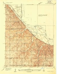
 1934 Bonner Springs1934 Print · USGSLeavenworth and Wyandotte counties are shown in detail during the mid-1930s, capturing the rural landscape before post-war suburbanization. Researchers can trace family homesteads near Fairmount, Lansing, and local landmarks like Coal Ridge Sch or Hoge Sch.
 - 1934 Map of Shawnee
 1934 Shawnee1934 Print · USGSThe Kansas River valley and the developing suburbs of Johnson County are shown in detail during the early 1930s. Researchers can trace historic neighborhoods and transit lines including Merriam, Argentine High Sch, and the Kansas and Missouri Interurban.3 unique versions available
 - 1934 Map of Edwardsville
 1934 Edwardsville1934 Print · USGSMid-century Wyandotte and Johnson counties are defined here by the winding river and a busy network of competing rail lines. Researchers can locate early family landmarks like St Patricks Ch, trace the settlement of Stony Point Village, or find the historic Wyandotte County Home.
 - 1934 Map of Wolcott
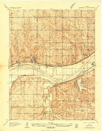
 1934 Wolcott1934 Print · USGSThe Missouri River bottoms and the uplands of Wyandotte County appear here as they were in the mid-1930s. Researchers can trace the path of the Missouri Pacific RR and locate rural landmarks like White Church and the Kansas State Prison Camp No 2.
 - 1935 Map of Kansas City
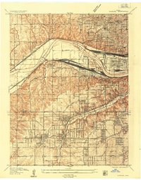
 1935 Kansas City1935 Print · USGSKansas City and its surrounding Missouri and Kansas neighborhoods are captured here during a period of significant civic expansion in the mid-1930s. Researchers can trace the layout of early aviation at the Municipal Landing Field or locate family history through many landmarks like Elmwood Cem and Wyandotte High Sch.2 unique versions available
 - 1935 Map of North Kansas City
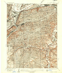
 1935 North Kansas City1935 Print · USGSNorth Kansas City and the Missouri River bluffs appear here in the mid-1930s as industrial development begins to reshape the river valley. You can trace early aviation sites like Fairfax Landing Field and community anchors like Gashland Sch and Winnwood Lake.
End of results
Showing maps 1-6 of 6
Top cities of Wyandotte County
Frequently asked questions
- What are the different types of historical maps available for Wyandotte County?
- What is the oldest map of Wyandotte County?
- Where can I purchase historical maps of Wyandotte County for my home or office?
- Where can I download high-res historical maps of Wyandotte County?
- Are there historical topographic maps available for Wyandotte County?
- Is there historical aerial imagery available for Wyandotte County?
- Where are historical maps of Wyandotte County sourced from?