1970s Maps of Anderson County, Kentucky
Explore 4 historic maps of Anderson County from the 1970s. These maps offer a rare glimpse into what life looked like during the 1970s — showing old roads, neighborhoods, homes, and landmarks that have changed or disappeared over time.
Whether you're researching your family's past, planning a metal detecting trip, or studying how Anderson County's landscape evolved across the 1970s, these high-resolution maps are a powerful tool for exploring the history of this region.
- Focus on a specific era: All maps on this page are from the 1970s, giving you a focused view of this time period.
- See what’s changed: Compare century-old streets, trails, and buildings to today's modern landscape using overlays and satellite layers.
- Research with precision: Use these maps for genealogy, historical research, land use analysis, or educational projects.
- View, download, or print: Maps are fully viewable online in high resolution, and can be downloaded or printed for your own records.
Start exploring Anderson County's history through authentic maps from the 1970s. This is your window into the past.
Anderson County, KY maps
(4)- 1970 Map of Frankfort West, 1972 Print
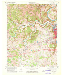 1970 Frankfort West1972 Print · USGSThe Kentucky state capital and its rural western environs are captured here in the early seventies as the city expanded toward Pea Ridge. Genealogists can trace family landmarks like Sudduth Cem and rural centers such as Bridgeport and Choateville.5 unique versions available
 - 1972 Map of Ashbrook, 1973 Print
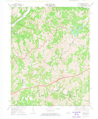 1972 Ashbrook1973 Print · USGSAnderson and Washington counties are captured here in the early 1970s as the Blue Grass Parkway reshaped the rural landscape. Researchers can trace historic local hubs like Ashbrook, Sinai, and Johnsonville alongside old schools like Western Sch.3 unique versions available
 - 1972 Map of Chaplin, 1974 Print
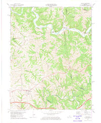 1972 Chaplin1974 Print · USGSCentral Kentucky's river valleys and rural uplands are captured here in the early seventies, spanning four county lines. Researchers can trace family roots through numerous small cemeteries and country churches like Highview Ch, Green Chapel, and Price Cem.2 unique versions available
 - 1976 Map of Tyrone, 1980 Print
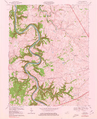 1976 Tyrone1980 Print · USGSMid-century Woodford and Anderson Counties are defined here by the winding Kentucky River and the riverfront industry of Tyrone. Trace the heritage of the Bluegrass region through local landmarks like Lock No 5, Glenns Creek Ch, and the small community of Millville.
End of results
Showing maps 1-4 of 4
Top cities of Anderson County
Frequently asked questions
- What are the different types of historical maps available for Anderson County?
- What is the oldest map of Anderson County?
- Where can I purchase historical maps of Anderson County for my home or office?
- Where can I download high-res historical maps of Anderson County?
- Are there historical topographic maps available for Anderson County?
- Is there historical aerial imagery available for Anderson County?
- Where are historical maps of Anderson County sourced from?