1900s (20th Century) Maps of Owingsville, Kentucky
Explore 10 historic maps of Owingsville from the 1900s (20th Century). These maps offer a rare glimpse into what life looked like during the 1900s — showing old roads, neighborhoods, homes, and landmarks that have changed or disappeared over time.
Whether you're researching your family's past, planning a metal detecting trip, or studying how Owingsville's landscape evolved across the 1900s, these high-resolution maps are a powerful tool for exploring the history of this region.
- Focus on a specific era: All maps on this page are from the 1900s, giving you a focused view of this time period.
- See what’s changed: Compare century-old streets, trails, and buildings to today's modern landscape using overlays and satellite layers.
- Research with precision: Use these maps for genealogy, historical research, land use analysis, or educational projects.
- View, download, or print: Maps are fully viewable online in high resolution, and can be downloaded or printed for your own records.
Start exploring Owingsville's history through authentic maps from the 1900s. This is your window into the past.
Owingsville, KY maps
(10)- 1929 Map of Salt Lick, 1961 Print
 1929 Salt Lick1961 Print · USGSBath and Fleming counties are shown here as the Licking River valley was transitioning into a modern rail corridor. Genealogists and historians can trace numerous rural schoolhouses and river crossings like Moores Ferry, Arnold Chapel, and the historic Olympia Springs.
 - 1934 Map of Salt Lick
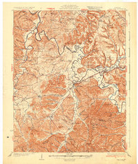 1934 Salt Lick1934 Print · USGSNortheastern Kentucky’s river valleys and ridgelines are captured here in the 1930s, centered on the vital rail corridor through Salt Lick. Genealogists and historians can trace dozens of rural schoolhouses and churches, including Arnold Chapel Sch, Olympia Springs, and Moores Ferry on the Licking River.
 - 1952 Map of Preston, 1953 Print
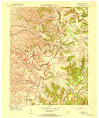 1952 Preston1953 Print · USGSBath and Montgomery counties are captured here in the early fifties, showing a rural landscape shaped by the winding Slate Creek and the Chesapeake and Ohio rail line. Genealogists can locate family landmarks like Treadway Cem or trace old community sites such as Peeled Oak and Howards Mill.
 - 1952 Map of Owingsville, 1953 Print
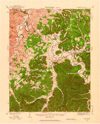
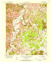
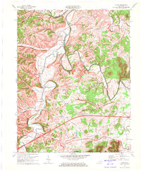
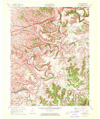
 1952 Owingsville1953 Print · USGSOwingsville and the surrounding Kentucky countryside are captured here in the early fifties, following the path of the historic Midland Trail. Genealogists and local historians can trace old homesteads and landmarks like Hendricks Cem, Reynoldsville, and Tunnel Hill Ch.4 unique versions available
 - 1953 Map of Colfax, 1955 Print
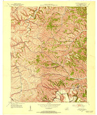
 1953 Colfax1955 Print · USGSBath and Fleming Counties during the early fifties show a landscape of winding river valleys and ridge-top schools. Genealogists can trace family names at the Atchison Cem or locate community centers like Slate Valley and Baileys Chapel.
 - 1957 Map of Huntington, 1966 Print
 1957 Huntington1966 Print · USGSThe industrial heart of the Ohio River valley is captured here in the mid-sixties, showing the growth of Huntington and Ashland. Researchers can trace the extensive rail networks of the Chesapeake and Ohio RR and locate sites like the Chief Cornstalk Hunting Ground.3 unique versions available
 - 1960 Map of Huntington
 1960 Huntington1960 Print · USGSThe tri-state river valley thrived in the late fifties as a hub of heavy industry and Appalachian rail transit. Genealogists and historians can trace the connection between river towns like Ashland and Portsmouth or locate family homesteads near Coleman Ridge.
 - 1970 Map of Colfax, 1972 Print
 1970 Colfax1972 Print · USGSBath and Fleming Counties appear here in the early seventies, as rural life moved along the high ridges and deep hollows of the Licking River. Genealogists and historians can trace local family lineages through remote sites like Old Virginia Cem, Grange City, and Atchison Cem.2 unique versions available
 - 1970 Map of Preston, 1972 Print
 1970 Preston1972 Print · USGSBath and Montgomery Counties appear here in the early 1970s, showing a rural landscape shaped by the winding Slate Creek. Researchers can locate family landmarks like Peeled Oak Cem, the Stepstone Sch, and the rail corridor of the Chesapeake and Ohio.2 unique versions available
 - 1982 Map of Morehead, 1983 Print
 1982 Morehead1983 Print · USGSThe foothills of northeastern Kentucky come alive in the early eighties, showcasing a landscape defined by timber, limestone caves, and major reservoirs. Local researchers can trace the development of Morehead State University or locate old crossings at Plummers Mill and Salt Lick.
End of results
Showing maps 1-10 of 10
Top cities near Owingsville
- Mount Sterling historical maps
- Jeffersonville historical maps
- Camargo historical maps
- Frenchburg historical maps
- Salt Lick historical maps
- Sharpsburg historical maps
Frequently asked questions
- What are the different types of historical maps available for Owingsville?
- What is the oldest map of Owingsville?
- Where can I purchase historical maps of Owingsville for my home or office?
- Where can I download high-res historical maps of Owingsville?
- Are there historical topographic maps available for Owingsville?
- Is there historical aerial imagery available for Owingsville?
- Where are historical maps of Owingsville sourced from?