1970s Maps of Salt Lick, Kentucky
Explore 2 historic maps of Salt Lick from the 1970s. These maps offer a rare glimpse into what life looked like during the 1970s — showing old roads, neighborhoods, homes, and landmarks that have changed or disappeared over time.
Whether you're researching your family's past, planning a metal detecting trip, or studying how Salt Lick's landscape evolved across the 1970s, these high-resolution maps are a powerful tool for exploring the history of this region.
- Focus on a specific era: All maps on this page are from the 1970s, giving you a focused view of this time period.
- See what’s changed: Compare century-old streets, trails, and buildings to today's modern landscape using overlays and satellite layers.
- Research with precision: Use these maps for genealogy, historical research, land use analysis, or educational projects.
- View, download, or print: Maps are fully viewable online in high resolution, and can be downloaded or printed for your own records.
Start exploring Salt Lick's history through authentic maps from the 1970s. This is your window into the past.
Salt Lick, KY maps
(2)- 1970 Map of Farmers, 1972 Print
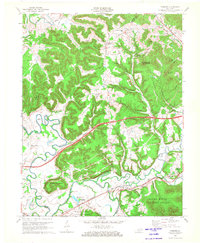 1970 Farmers1972 Print · USGSRowan and Bath counties in the early seventies reveal a landscape of river-bend settlements and deep forest ridges. Genealogists and locals can trace family sites like Eldridge Cem, find the old crossing at Moores Ferry, and follow the Chesapeake and Ohio rail line.2 unique versions available
 - 1975 Map of Salt Lick, 1977 Print
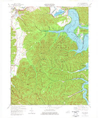 1975 Salt Lick1977 Print · USGSBath and Rowan counties in the mid-seventies reveal a landscape reshaped by the waters of Cave Run Lake and the Licking River. Genealogists and historians can trace the C & O rail corridor and find local sites like Clear Creek Furnace and Upper Salt Lick Ch.
End of results
Showing maps 1-2 of 2
Top cities near Salt Lick
- Morehead historical maps
- Jeffersonville historical maps
- Owingsville historical maps
- Frenchburg historical maps
- Lakeview Heights historical maps
Frequently asked questions
- What are the different types of historical maps available for Salt Lick?
- What is the oldest map of Salt Lick?
- Where can I purchase historical maps of Salt Lick for my home or office?
- Where can I download high-res historical maps of Salt Lick?
- Are there historical topographic maps available for Salt Lick?
- Is there historical aerial imagery available for Salt Lick?
- Where are historical maps of Salt Lick sourced from?