1950s Maps of Salt Lick, Kentucky
Explore 3 historic maps of Salt Lick from the 1950s. These maps offer a rare glimpse into what life looked like during the 1950s — showing old roads, neighborhoods, homes, and landmarks that have changed or disappeared over time.
Whether you're researching your family's past, planning a metal detecting trip, or studying how Salt Lick's landscape evolved across the 1950s, these high-resolution maps are a powerful tool for exploring the history of this region.
- Focus on a specific era: All maps on this page are from the 1950s, giving you a focused view of this time period.
- See what’s changed: Compare century-old streets, trails, and buildings to today's modern landscape using overlays and satellite layers.
- Research with precision: Use these maps for genealogy, historical research, land use analysis, or educational projects.
- View, download, or print: Maps are fully viewable online in high resolution, and can be downloaded or printed for your own records.
Start exploring Salt Lick's history through authentic maps from the 1950s. This is your window into the past.
Salt Lick, KY maps
(3)- 1953 Map of Farmers, 1954 Print
 1953 Farmers1954 Print · USGSThe borderlands of Rowan, Bath, and Fleming counties are captured here in the early fifties, centered on the rail-and-river hub of Farmers. Local researchers can trace family roots through sites like Jones Cemetery, Moores Ferry, and the Three Lick School.2 unique versions available
 - 1953 Map of Salt Lick, 1954 Print
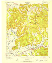
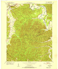 1953 Salt Lick1954 Print · USGSBath County at the start of the fifties shows a landscape where timber and rail define the community. Researchers can locate the C & O railroad through Salt Lick, the Tater Knob Lookout Tower, and burial sites like Dickerson Cem.2 unique versions available
 - 1957 Map of Huntington, 1966 Print
 1957 Huntington1966 Print · USGSThe industrial heart of the Ohio River valley is captured here in the mid-sixties, showing the growth of Huntington and Ashland. Researchers can trace the extensive rail networks of the Chesapeake and Ohio RR and locate sites like the Chief Cornstalk Hunting Ground.3 unique versions available
End of results
Showing maps 1-3 of 3
Top cities near Salt Lick
- Morehead historical maps
- Jeffersonville historical maps
- Owingsville historical maps
- Frenchburg historical maps
- Lakeview Heights historical maps
Frequently asked questions
- What are the different types of historical maps available for Salt Lick?
- What is the oldest map of Salt Lick?
- Where can I purchase historical maps of Salt Lick for my home or office?
- Where can I download high-res historical maps of Salt Lick?
- Are there historical topographic maps available for Salt Lick?
- Is there historical aerial imagery available for Salt Lick?
- Where are historical maps of Salt Lick sourced from?