1930s Maps of Bell County, Kentucky
Explore 6 historic maps of Bell County from the 1930s. These maps offer a rare glimpse into what life looked like during the 1930s — showing old roads, neighborhoods, homes, and landmarks that have changed or disappeared over time.
Whether you're researching your family's past, planning a metal detecting trip, or studying how Bell County's landscape evolved across the 1930s, these high-resolution maps are a powerful tool for exploring the history of this region.
- Focus on a specific era: All maps on this page are from the 1930s, giving you a focused view of this time period.
- See what’s changed: Compare century-old streets, trails, and buildings to today's modern landscape using overlays and satellite layers.
- Research with precision: Use these maps for genealogy, historical research, land use analysis, or educational projects.
- View, download, or print: Maps are fully viewable online in high resolution, and can be downloaded or printed for your own records.
Start exploring Bell County's history through authentic maps from the 1930s. This is your window into the past.
Bell County, KY maps
(6)- 1930 Map of Middlesboro
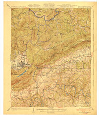 1930 Middlesboro1930 Print · USGSThe tri-state border region comes alive in the late 1920s, centered on the strategic mountain pass at Cumberland Gap. Genealogists and historians can trace family locations near Middlesboro, early campus sites at Lincoln Memorial University, and rural landmarks like Ellison Mill.4 unique versions available
 - 1932 Map of Hagan
 1932 Hagan1932 Print · USGSThe rugged borderlands of Kentucky and Virginia come to life in this early 1930s survey of the high gaps and hollows. Researchers can locate remote mountain landmarks like Hensley Sch, Feepee Store, and the scattered cabins at Alva.3 unique versions available
 - 1935 Map of Ewing
 1935 Ewing1935 Print · USGSThe Virginia-Kentucky borderlands in the mid-1930s are captured here, centered on the settlement of Ewing and the passage through Poor Valley. Trace the path of the Old Wilderness Trail and locate family landmarks like Mc Lin Cem and Arthur Chapel.
 - 1935 Map of Varilla
 1935 Varilla1935 Print · USGSThe Kentucky and Virginia state line was defined by the high ridgelines of the Appalachians in the mid-1930s. Genealogists can trace family landmarks and rural infrastructure including Ely Cem, Woodvine Sch, and the Trent Siding along the rail line.
 - 1935 Map of Mingo Mountains
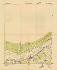
 1935 Mingo Mountains1935 Print · USGSClaiborne County, Tennessee, is captured in the mid-1930s as the Tennessee Valley Authority began its work in the region. Researchers can locate family landmarks like Alexander Cem, the Powell Valley Sch, and the waters of Van Babber Spring.
 - 1935 Map of Cumberland Gap
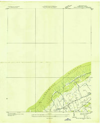
 1935 Cumberland Gap1935 Print · USGSThe tri-state corner of Tennessee, Kentucky, and Virginia comes alive in the mid-1930s as the Tennessee Valley Authority begins transforming the Powell River valley. Trace the legendary Wilderness Trail past Lincoln Memorial University or locate family sites like Minton Mill and Sproles Chapel Sch.
End of results
Showing maps 1-6 of 6
Top cities of Bell County
Frequently asked questions
- What are the different types of historical maps available for Bell County?
- What is the oldest map of Bell County?
- Where can I purchase historical maps of Bell County for my home or office?
- Where can I download high-res historical maps of Bell County?
- Are there historical topographic maps available for Bell County?
- Is there historical aerial imagery available for Bell County?
- Where are historical maps of Bell County sourced from?