Old Maps of Boyd County, Kentucky for Academic Research
Study the evolution of Boyd County with 88 high-resolution historic maps. Whether you're teaching, researching, or modeling changes in land use, these maps provide essential visual documentation of urban, environmental, and geographic change.
- Analyze long-term change: Track patterns in development, transportation, and natural features.
- Ideal for environmental or urban studies: Support academic projects with primary historical map data.
- Use in the classroom or lab: Educators and researchers rely on these maps to bring historical context to life.
These maps are a powerful tool for teaching, research, and visualizing how Boyd County has changed over the decades.
Boyd County, KY maps
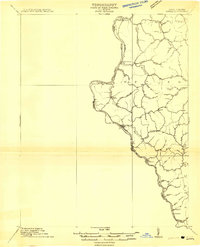
(88)- 1898 Map of Ironton, 1955 Print
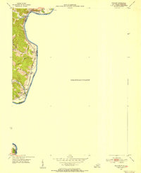
 1898 Ironton1955 Print · USGSSouthern Ohio's iron-producing region and the bustling riverfront at Ironton are documented here just before the turn of the century. Genealogists can trace family footprints near Vesuvius Furnace, Woodland Cemetery, and old post offices like Culbertson P.O.
 - 1900 Map of Ironton, 1918 Print
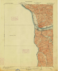
 1900 Ironton1918 Print · USGSThe Ohio River valley and the iron-rich hills of Lawrence County are seen here at the turn of the century during a peak in industrial activity. Genealogists and historians can trace defunct post offices like Orr P.O. and explore the rail corridors of the Ironton R.R. and Cincinnati Hamilton & Dayton R.R.2 unique versions available
 - 1901 Map of Ceredo, 1953 Print
 1901 Ceredo1953 Print · USGSThe tri-state convergence of West Virginia, Ohio, and Kentucky comes alive in this early 20th-century survey of the Ohio River valley. Genealogists and rail historians can trace the vital transport networks of Kenova and Ceredo, alongside family-named landmarks like Walker Br and Rice Run.2 unique versions available
 - 1903 Map of Kenova
 1903 Kenova1903 Print · USGSThe tri-state river junction at Ashland and Kenova was a bustling industrial hub after the turn of the century. Trace early rail lines and mining settlements like Coalton and Boghead, or locate family landmarks along the Little Sandy River and Means Tunnel.5 unique versions available
 - 1904 Map of Kenova
 1904 Kenova1904 Print · USGSThe tri-state confluence of the Ohio River and Big Sandy River hums with early industrial activity at the start of the century. Genealogists can trace rail-side settlements and remote homesteads along Blaine Creek and near Mt Savage or Webbville.
 - 1911 Map of Louisa
 1911 Louisa1911 Print · USGSThe West Virginia borderlands along the Big Sandy River come to life in this early twentieth-century study of Wayne County. Trace family roots and vanished rail stops like Fort Gay, Glenhayes, and Saltpeter along the Norfolk and Western Railway line.
 - 1913 Map of Ceredo
 1913 Ceredo1913 Print · USGSThe confluence of the Ohio and Big Sandy rivers comes alive in this pre-war survey of the West Virginia-Ohio borderlands. Genealogists and rail historians can trace the early footprints of Kenova, Ceredo, and the winding path of Twelvepole Creek.4 unique versions available
 - 1913 Map of Louisa
 1913 Louisa1913 Print · USGSThe river borders of West Virginia and Kentucky come alive in this pre-World War I survey of the Big Sandy valley. Genealogists can trace family footprints in Fort Gay, Saltpeter, and Glenhayes or locate the rural Buck Church.3 unique versions available
 - 1939 Map of Louisa
 1939 Louisa1939 Print · USGSThe borderlands of West Virginia and Kentucky are captured here in the late thirties, centered on the river junctions. Researchers can trace family ties at small rural sites like Double Cabin Sch, Elijah Ch, and the settlement of Fort Gay.3 unique versions available
 - 1953 Map of Prichard, 1954 Print
 1953 Prichard1954 Print · USGSThe Big Sandy River corridor comes into focus in the early 1950s as a vital transportation link between Kentucky and West Virginia. Genealogists and rail historians can trace the paths of the Norfolk and Western railroad and locate local landmarks like Buchanan Chapel and Catalpa.2 unique versions available
 - 1953 Map of Rush, 1955 Print
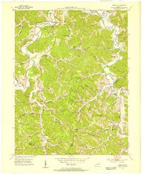
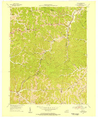 1953 Rush1955 Print · USGSEastern Kentucky's coal and gas country comes into focus during the early fifties along the Chesapeake and Ohio line. Genealogists can locate family landmarks such as Gravel Lick Cemetery and Geigersville School among the active Strip Mines.2 unique versions available
 - 1953 Map of Boltsfork, 1955 Print
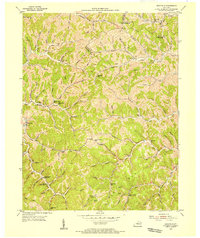
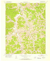 1953 Boltsfork1955 Print · USGSBoyd and Lawrence Counties are shown in the early fifties as the region's energy economy expanded through large gas fields and strip mines. Genealogists can trace family roots through dozens of local cemeteries and landmarks like Mt Olive Ch, Mavity, and Ararat Sch.2 unique versions available
 - 1953 Map of Ashland, 1955 Print
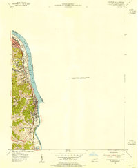
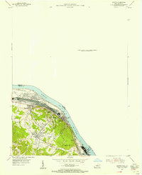
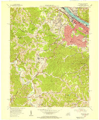 1953 Ashland1955 Print · USGSAshland was a thriving river and rail hub during the mid-fifties, dominated by its industrial waterfront and expanding hillside suburbs. Local researchers can trace family roots through the Rose Hill Burial Park, Summit settlement, and the grounds of the Federal Correctional Institution.
 - 1953 Map of Argillite, 1955 Print
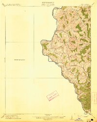
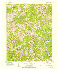
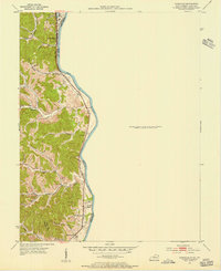
 1953 Argillite1955 Print · USGSGreenup and Boyd County during the early fifties show a rural landscape transitioning between the old iron furnace era and modern coal mining. Genealogists can trace family landmarks like Reeves Cem and Howard Cem alongside numerous country schools such as Palmyra Sch and Montgomery Sch.
 - 1953 Map of Webbville, 1955 Print
 1953 Webbville1955 Print · USGSLawrence County saw a landscape of remote hollows and narrow creek-side settlements in the early fifties. Genealogists and historians can trace family locations through named sites like Pollys Chapel, Hammond Cem, and the Old Kentucky Home Sch.3 unique versions available
 - 1953 Map of Catlettsburg, 1955 Print
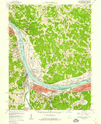
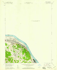
 1953 Catlettsburg1955 Print · USGSThe industrial riverfront of northeastern Kentucky is captured here just after the war, where the Ohio and Big Sandy rivers converge. Researchers can trace the mid-century footprint of Catlettsburg and Ashland alongside landmarks like England Hill Sch and Lock No 29.
 - 1953 Map of Fallsburg, 1955 Print
 1953 Fallsburg1955 Print · USGSLawrence County, Kentucky, is shown in the early fifties as a landscape defined by its deep hollows and creek-side settlements. Genealogists can locate family landmarks like Garret Chapel, Dennis Sch, and the scattered communities of Yatesville and Five Forks.2 unique versions available
 - 1953 Map of Ironton, 1955 Print
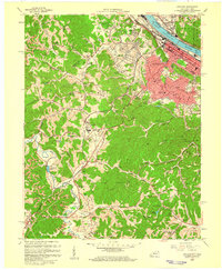
 1953 Ironton1955 Print · USGSThe Ohio River bank was a hive of industrial and residential growth in the early fifties as the railroad and river trade intersected. Trace the development of communities like Flatwoods and Russell or locate family burial sites at Rude Cem and Baldridge Cem.
 - 1953 Map of Burnaugh, 1956 Print
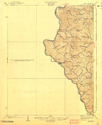
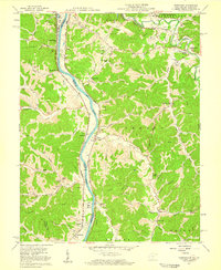
 1953 Burnaugh1956 Print · USGSBoyd County's riverfront and hill country are captured here in the early fifties, following the Big Sandy River and its rail corridor. Genealogists can locate family landmarks like Clarkson Cem, Hall Cem, and the community of Kavanaugh.
 - 1957 Map of Catlettsburg, 1958 Print
 1957 Catlettsburg1958 Print · USGSThe tri-state river junction comes alive in the late fifties, showing the industrial heart of the OHIO RIVER valley. Genealogists and historians can trace family roots through the England Hill Sch, Williams Cem, and the historic streets of Kenova.2 unique versions available
 - 1957 Map of Burnaugh, 1959 Print
 1957 Burnaugh1959 Print · USGSThe tri-state border region along the Big Sandy River comes alive in the late fifties, showing the convergence of rail, river, and mountain life. Trace family history through dozens of landmarks like Cyrus Chapel, Durbin Sch, and the U S Veterans Hospital.2 unique versions available
 - 1957 Map of Huntington, 1966 Print
 1957 Huntington1966 Print · USGSThe industrial heart of the Ohio River valley is captured here in the mid-sixties, showing the growth of Huntington and Ashland. Researchers can trace the extensive rail networks of the Chesapeake and Ohio RR and locate sites like the Chief Cornstalk Hunting Ground.3 unique versions available
 - 1958 Map of Ashland, 1959 Print
 1958 Ashland1959 Print · USGSAshland and the Ohio River valley are shown here during a mid-century period of heavy rail traffic and institutional growth. Researchers can locate the Federal Correctional Institution, numerous hillside Strip Mines, and local landmarks like Rose Hill Burial Park.
 - 1958 Map of Ironton, 1959 Print
 1958 Ironton1959 Print · USGSThe Ohio River valley was undergoing a mid-century industrial and residential shift in the late fifties. Genealogists and historians can trace family roots through sites like Indian Run Ch, the Bellefonte Memorial Cem, and Caroline Sch.
 - 1960 Map of Huntington
 1960 Huntington1960 Print · USGSThe tri-state river valley thrived in the late fifties as a hub of heavy industry and Appalachian rail transit. Genealogists and historians can trace the connection between river towns like Ashland and Portsmouth or locate family homesteads near Coleman Ridge.
Showing maps 1-25 of 88
Top cities of Boyd County
Frequently asked questions
- What are the different types of historical maps available for Boyd County?
- What is the oldest map of Boyd County?
- Where can I purchase historical maps of Boyd County for my home or office?
- Where can I download high-res historical maps of Boyd County?
- Are there historical topographic maps available for Boyd County?
- Is there historical aerial imagery available for Boyd County?
- Where are historical maps of Boyd County sourced from?