
1898 Map of Ironton
USGS Topo · Published 1955About this map
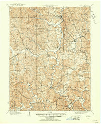
The industrial heart of southern Ohio along the Ohio River is captured here during the late nineteenth century, dominated by the iron-producing economy of the Hanging Rock region. Ironton serves as the primary hub, where the Dayton Hamilton & Cincinnati R.R. and Ironton R.R. converge to move ore and finished goods. The map reveals a landscape defined by its furnaces, including Vesuvius Furnace and Center Furnace, which were critical to the area's charcoal iron industry.
Find a feature on this map
83 named features on this map. Tap any name to fly to it.
Don’t see what you’re looking for? This feature index may not catch every label — zoom into the map to look around manually.
Map Details
Editions of this 1898 Ironton Map
This is the sole edition of this map. No revisions or reprints were ever made.
Other maps of this area

1892 · Huntington
USGS Topo · 1:125,000

1898 · Huntington
USGS Topo · 1:125,000

1900 · Ironton
USGS Topo · 1:62,500

1901 · Guyandot
USGS Topo · 1:62,500

1901 · Ceredo
USGS Topo · 1:62,500

1902 · Guyandot
USGS Topo · 1:62,500

1903 · Kenova
USGS Topo · 1:125,000

1904 · Kenova
USGS Topo · 1:125,000
1906 · Bidwell
USGS Topo · 1:62,500

1906 · Athalia
USGS Topo · 1:62,500