
1898 Map of Huntington
USGS Topo · Published 1898About this map
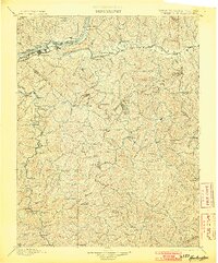
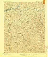
The Ohio River serves as the bustling corridor of commerce and settlement in the late nineteenth century, bordering the growing hub of Huntington. This survey, conducted by topographer L.C. Fletcher, illustrates a landscape defined by its waterways and rail connections. The Chesapeake and Ohio RR follows the southern bank of the Ohio, linking riverside communities like Guyandot and Barboursville to the interior. Further east along the Mud River, the railroad supports the growth of Milton and Hurricane, while the county seat at Hamlin remains a vital inland center.
Find a feature on this map
139 named features on this map. Tap any name to fly to it.
Don’t see what you’re looking for? This feature index may not catch every label — zoom into the map to look around manually.
Map Details
Editions of this 1898 Huntington Map
3 editions found
Other maps of this area

1886 · Prestonsburg
USGS Topo · 1:125,000

1887 · Warfield
USGS Topo · 1:125,000

1891 · Oceana
USGS Topo · 1:125,000

1891 · Warfield
USGS Topo · 1:125,000

1892 · Prestonsburg
USGS Topo · 1:125,000

1892 · Huntington
USGS Topo · 1:125,000

1893 · Oceana
USGS Topo · 1:125,000

1898 · Oceana
USGS Topo · 1:125,000

1898 · Ironton
USGS Topo · 1:62,500

1899 · Charleston
USGS Topo · 1:125,000