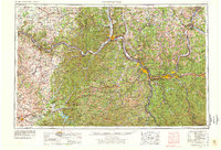
1957 Map of Huntington
USGS Topo · Published 1978About this map
The Ohio River valley serves as the industrial and transportation spine of this tri-state region, connecting Huntington, Ashland, and Portsmouth during a period of significant post-war infrastructure. The map reveals a landscape defined by the heavy rail corridors of the Chesapeake & Ohio RR and Norfolk & Western RR, which trace the riverbanks alongside established river towns like Ironton and Catlettsburg. Beyond the industrial riverside, the terrain rises into the deep ridges of the Wayne National Forest and Daniel Boone National Forest. Notable landmarks such as Sugarloaf Mtn and Pilot Knob punctuate the highlands, while newer hydrological features like Grayson Lake and Cave Run Lake reflect mid-century changes to the drainage basins of the Little Sandy River and Licking River.
Find a feature on this map
123 named features on this map. Tap any name to fly to it.
Don’t see what you’re looking for? This feature index may not catch every label — zoom into the map to look around manually.
Map Details
Editions of this 1957 Huntington Map
3 editions found

Other maps of this area

1886 · Prestonsburg
USGS Topo · 1:125,000

1887 · Warfield
USGS Topo · 1:125,000

1889 · Salyersville
USGS Topo · 1:125,000

1891 · Oceana
USGS Topo · 1:125,000

1891 · Salyersville
USGS Topo · 1:125,000

1891 · Warfield
USGS Topo · 1:125,000

1892 · Richmond
USGS Topo · 1:125,000

1892 · Prestonsburg
USGS Topo · 1:125,000

1892 · Beattyville
USGS Topo · 1:125,000

1892 · Huntington
USGS Topo · 1:125,000