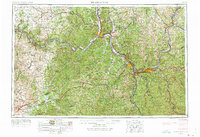
1957 Map of Huntington
USGS Topo · Published 1973About this map
The Ohio River valley serves as the central artery for this 1957 Army Map Service compilation, anchoring a industrial and transportation corridor through West Virginia, Kentucky, and Ohio. Industrial hubs like Huntington and Ashland are shown at a peak moment of rail-and-river connectivity, where the Chesapeake and Ohio RR and Norfolk and Western RR parallel the water. The map traces the confluence of the Big Sandy River and the Scioto River, marking the boundaries between these three states.
Find a feature on this map
69 named features on this map. Tap any name to fly to it.
Don’t see what you’re looking for? This feature index may not catch every label — zoom into the map to look around manually.
Map Details
Editions of this 1957 Huntington Map
3 editions found

Other maps of this area

1886 · Prestonsburg
USGS Topo · 1:125,000

1887 · Warfield
USGS Topo · 1:125,000

1889 · Salyersville
USGS Topo · 1:125,000

1891 · Oceana
USGS Topo · 1:125,000

1891 · Salyersville
USGS Topo · 1:125,000

1891 · Warfield
USGS Topo · 1:125,000

1892 · Richmond
USGS Topo · 1:125,000

1892 · Prestonsburg
USGS Topo · 1:125,000

1892 · Beattyville
USGS Topo · 1:125,000

1892 · Huntington
USGS Topo · 1:125,000