Loading...
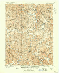
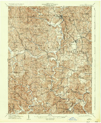
Loading map...1906 Map of Bidwell
USGS Topo · Published 1954About this map
Raccoon Creek and its complex network of tributaries, such as Little Raccoon Creek and Indian Creek, dominate the rural topography of Gallia County at the turn of the century. This landscape is defined by small, frequent settlements linked by the Gallipolis and Chillicothe RR, including Bidwell and Vinton. The prevalence of dual-named post offices like Centerville Thurman PO and Pinegrove PO indicates a period of shifting postal identities in these southeastern Ohio townships.
Find a feature on this map
92 named features on this map. Tap any name to fly to it.
Don’t see what you’re looking for? This feature index may not catch every label — zoom into the map to look around manually.
Map Details
Date Portrayed1906
Date Published1954
PublisherU.S. Geological Survey
Map TypeTopographic
Scale1:62,500
Physical Dimensions17 x 20.9 inches
Editions of this 1906 Bidwell Map
This is the sole edition of this map. No revisions or reprints were ever made.
Historical Maps of Rio Grande Through Time
Featured Locations
Source Details
SourceU.S. Geological Survey
CopyrightPublic Domain