1960s Maps of Bracken County, Kentucky
Explore 5 historic maps of Bracken County from the 1960s. These maps offer a rare glimpse into what life looked like during the 1960s — showing old roads, neighborhoods, homes, and landmarks that have changed or disappeared over time.
Whether you're researching your family's past, planning a metal detecting trip, or studying how Bracken County's landscape evolved across the 1960s, these high-resolution maps are a powerful tool for exploring the history of this region.
- Focus on a specific era: All maps on this page are from the 1960s, giving you a focused view of this time period.
- See what’s changed: Compare century-old streets, trails, and buildings to today's modern landscape using overlays and satellite layers.
- Research with precision: Use these maps for genealogy, historical research, land use analysis, or educational projects.
- View, download, or print: Maps are fully viewable online in high resolution, and can be downloaded or printed for your own records.
Start exploring Bracken County's history through authentic maps from the 1960s. This is your window into the past.
Bracken County, KY maps
(5)- 1960 Map of Huntington
 1960 Huntington1960 Print · USGSThe tri-state river valley thrived in the late fifties as a hub of heavy industry and Appalachian rail transit. Genealogists and historians can trace the connection between river towns like Ashland and Portsmouth or locate family homesteads near Coleman Ridge.
 - 1961 Map of Higginsport, 1963 Print
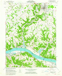 1961 Higginsport1963 Print · USGSThe Ohio River corridor comes alive in the early sixties as it winds between the riverfront communities of Higginsport, Augusta, and Dover. Researchers can trace the Chesapeake and Ohio rail line, rural family cemeteries like Sallee Cemetery, and the civic layout of Georgetown.3 unique versions available
 - 1964 Map of Louisville
 1964 Louisville1964 Print · USGSThe Ohio River valley and Kentucky Bluegrass are captured in the mid-1960s, showing a region balanced between industrial growth and its agrarian roots. Genealogists and historians can trace the development of county seats like Shelbyville and Paris, or locate established institutions such as Georgetown College and Bernheim Forest.
 - 1968 Map of Felicity, 1970 Print
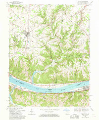 1968 Felicity1970 Print · USGSThe Ohio River valley and the rural uplands of Clermont and Bracken counties are captured here in the late sixties. Trace the riverside rail lines of the Chesapeake and Ohio or locate historic landmarks like Boude Ferry, Utopia, and Mt Zion Ch.2 unique versions available
 - 1968 Map of Moscow, 1971 Print
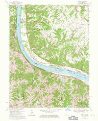 1968 Moscow1971 Print · USGSLife along the riverfront takes center stage in the late sixties as navigation and rail transport define this stretch of the Ohio valley. Researchers can trace family history through riverside towns and rural landmarks like Moscow Cem, the Chesapeake + Ohio railroad, and McKendree Cem Ch.2 unique versions available
End of results
Showing maps 1-5 of 5
Top cities of Bracken County
Frequently asked questions
- What are the different types of historical maps available for Bracken County?
- What is the oldest map of Bracken County?
- Where can I purchase historical maps of Bracken County for my home or office?
- Where can I download high-res historical maps of Bracken County?
- Are there historical topographic maps available for Bracken County?
- Is there historical aerial imagery available for Bracken County?
- Where are historical maps of Bracken County sourced from?