1950s Maps of Bracken County, Kentucky
Explore 11 historic maps of Bracken County from the 1950s. These maps offer a rare glimpse into what life looked like during the 1950s — showing old roads, neighborhoods, homes, and landmarks that have changed or disappeared over time.
Whether you're researching your family's past, planning a metal detecting trip, or studying how Bracken County's landscape evolved across the 1950s, these high-resolution maps are a powerful tool for exploring the history of this region.
- Focus on a specific era: All maps on this page are from the 1950s, giving you a focused view of this time period.
- See what’s changed: Compare century-old streets, trails, and buildings to today's modern landscape using overlays and satellite layers.
- Research with precision: Use these maps for genealogy, historical research, land use analysis, or educational projects.
- View, download, or print: Maps are fully viewable online in high resolution, and can be downloaded or printed for your own records.
Start exploring Bracken County's history through authentic maps from the 1950s. This is your window into the past.
Bracken County, KY maps
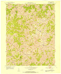
(11)- 1952 Map of Germantown, 1953 Print
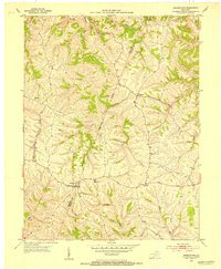 1952 Germantown1953 Print · USGSBracken and Mason Counties are shown here in the early fifties, where the hill-and-hollow topography dictates the local road network. Genealogists and historians can trace family locations near Germantown, the old Fairgrounds, and rural landmarks like Sharon Ch.2 unique versions available
 - 1952 Map of Higginsport, 1953 Print
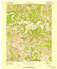
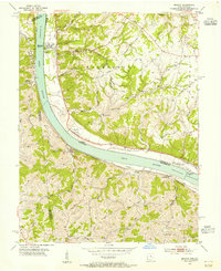
 1952 Higginsport1953 Print · USGSThe Ohio River borderlands of Kentucky and Ohio come into focus in the early 1950s, showing the riverside rail and road networks. Genealogists and local historians can trace family locations near Augusta, Dover, and the Rosemont Cem on the Kentucky shore.
 - 1952 Map of Sardis, 1953 Print
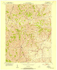 1952 Sardis1953 Print · USGSKentucky's ridge-and-hollow landscape comes into sharp focus in the early fifties at the junction of Mason, Bracken, and Robertson counties. Family historians can trace rural home sites and community landmarks like Salem Ch, Abigail, and the winding North Fork Licking River.2 unique versions available
 - 1952 Map of Mount Olivet, 1954 Print
 1952 Mount Olivet1954 Print · USGSMount Olivet and the surrounding Robertson County hills are captured here in the early fifties. Researchers can trace the rural landscape's family-named landmarks and community hubs, from Fosters Chapel and McKindree Ch to the small settlement at Santa Fe.
 - 1952 Map of Berlin, 1954 Print
 1952 Berlin1954 Print · USGSBracken and Pendleton Counties are shown here in the early fifties, capturing a network of rural ridge-top settlements and winding creek valleys. Genealogists can trace family landmarks like Blackerby Cem, Bachelors Rest, and New Zion Ch.
 - 1952 Map of Brooksville, 1954 Print
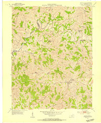
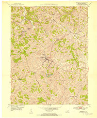 1952 Brooksville1954 Print · USGSBracken County ridge-top communities are captured here in the early fifties, showing the rural network of schools and churches. Genealogists can trace family roots through sites like Hamilton Cem, the County Home, and the village of Powersville.3 unique versions available
 - 1952 Map of Claysville, 1954 Print
 1952 Claysville1954 Print · USGSNorthern Kentucky's river valleys and ridgeline settlements are meticulously documented in the early fifties. Genealogists and local historians can trace family locations near Browning Corner, Milford, and country churches like Barlow Ch.2 unique versions available
 - 1953 Map of Felicity, 1955 Print
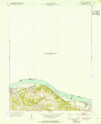
 1953 Felicity1955 Print · USGSThe Ohio River valley at the mid-century shows the river-and-rail economy of Clermont and Bracken counties. Researchers can trace the Chesapeake and Ohio line through Augusta or locate sites like Utopia, Boudes Ferry, and Mt Zion Ch.2 unique versions available
 - 1953 Map of Moscow, 1955 Print
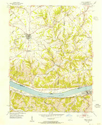
 1953 Moscow1955 Print · USGSThe Ohio River valley in the early fifties reveals a landscape defined by riverside rail travel and upland farming along the Ohio-Kentucky border. Genealogists can trace family sites at Vesper Cem and Flat Rock Ch, or locate old river works at Lock and Dam No 34.2 unique versions available
 - 1956 Map of Louisville, 1971 Print
 1956 Louisville1971 Print · USGSThe Ohio River valley and the Kentucky Bluegrass are captured here during a period of rapid mid-century growth and industrial activity. Genealogists and historians can trace rail-centered towns and military land use at Fort Knox and the Jefferson Proving Ground.2 unique versions available
 - 1957 Map of Huntington, 1966 Print
 1957 Huntington1966 Print · USGSThe industrial heart of the Ohio River valley is captured here in the mid-sixties, showing the growth of Huntington and Ashland. Researchers can trace the extensive rail networks of the Chesapeake and Ohio RR and locate sites like the Chief Cornstalk Hunting Ground.3 unique versions available
End of results
Showing maps 1-11 of 11
Top cities of Bracken County
Frequently asked questions
- What are the different types of historical maps available for Bracken County?
- What is the oldest map of Bracken County?
- Where can I purchase historical maps of Bracken County for my home or office?
- Where can I download high-res historical maps of Bracken County?
- Are there historical topographic maps available for Bracken County?
- Is there historical aerial imagery available for Bracken County?
- Where are historical maps of Bracken County sourced from?