1960s Maps of Breathitt County, Kentucky
Explore 13 historic maps of Breathitt County from the 1960s. These maps offer a rare glimpse into what life looked like during the 1960s — showing old roads, neighborhoods, homes, and landmarks that have changed or disappeared over time.
Whether you're researching your family's past, planning a metal detecting trip, or studying how Breathitt County's landscape evolved across the 1960s, these high-resolution maps are a powerful tool for exploring the history of this region.
- Focus on a specific era: All maps on this page are from the 1960s, giving you a focused view of this time period.
- See what’s changed: Compare century-old streets, trails, and buildings to today's modern landscape using overlays and satellite layers.
- Research with precision: Use these maps for genealogy, historical research, land use analysis, or educational projects.
- View, download, or print: Maps are fully viewable online in high resolution, and can be downloaded or printed for your own records.
Start exploring Breathitt County's history through authentic maps from the 1960s. This is your window into the past.
Breathitt County, KY maps
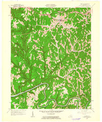
(13)- 1960 Map of Jenkins
 1960 Jenkins1960 Print · USGSEastern Kentucky and the West Virginia borderlands are captured at a mid-century peak of the coal and rail era. Trace the industrial corridors of the Chesapeake and Ohio RR through mountain hubs like Hazard and Jenkins.
 - 1961 Map of Quicksand
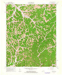
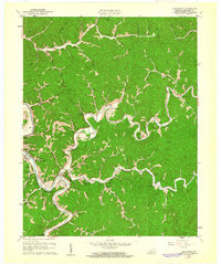 1961 Quicksand1961 Print · USGSBreathitt County in the early 1960s reveals a riverside landscape defined by the Kentucky River and its local branches. Genealogists can trace family landmarks like the Hardin Cem or the Wilstacy PO, alongside rural centers like the Rehoboth Mtn Mission.
 - 1961 Map of Cowcreek
 1961 Cowcreek1961 Print · USGSThe borderlands of Owsley and Breathitt counties are captured here in the early sixties, showing a landscape of deep valleys and creek-side homesteads. Researchers can trace the layout of Lerose, find the Houston Mission School, or locate the Forest Hill Community Center.
 - 1961 Map of Krypton, 1962 Print
 1961 Krypton1962 Print · USGSPerry County and the surrounding coalfields appear here in the early sixties, as the river-and-rail economy defined life along the mountain forks. Local historians can trace family roots at Red Hill Cem or locate vanished schoolhouses like Pigeonroost Sch and Butterfly Sch.
 - 1961 Map of Haddix, 1962 Print
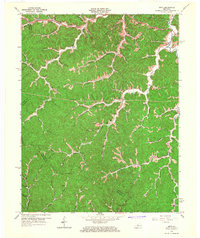
 1961 Haddix1962 Print · USGSBreathitt County in the early sixties was a landscape of coal mines and riverside rail depots connected by the winding Troublesome Creek. Genealogists and historians can trace family ties through Haddix Cem, locate the Riverside Christian Training Sch, and find old post offices like Copland (Saldee PO).
 - 1961 Map of Campton, 1963 Print
 1961 Campton1963 Print · USGSWolfe County settlement and the meandering NORTH FORK KENTUCKY RIVER take center stage in the early sixties. Genealogists can trace family landmarks like Quillins Chapel Sch, Booth Ridge, and Bethesda Mission across this dissected landscape.
 - 1961 Map of Tallega, 1963 Print
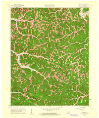
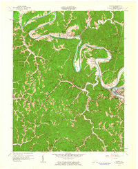
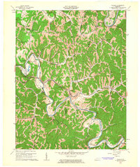 1961 Tallega1963 Print · USGSThe forks of the Kentucky River dominate this Breathitt County landscape in the early sixties as the railroad winds through the hills. Genealogists and historians can locate rural landmarks like Tallega Mission Sch, Gum Springs Bible Ch, and the engineering of the Tyler Tunnel.2 unique versions available
 - 1961 Map of Buckhorn, 1963 Print
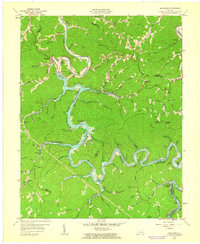 1961 Buckhorn1963 Print · USGSThe hills of Perry and Leslie counties are captured here just after the completion of the Buckhorn Dam and the filling of the reservoir. Genealogists can trace early mountain life through numerous rural schools like Strong Branch Sch and settlements at Bowlingtown and Saul.2 unique versions available
 - 1961 Map of Canoe, 1963 Print
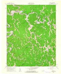
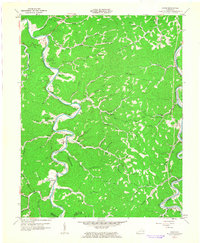 1961 Canoe1963 Print · USGSBreathitt County's serpentine river valleys and ridge-top lookouts are frozen in time here during the early sixties. Researchers can trace family homesteads and local landmarks like Beech PO, Shoulderblade Creek, and the Herald Cem.2 unique versions available
 - 1961 Map of Landsaw, 1963 Print
 1961 Landsaw1963 Print · USGSThe borderlands of Wolfe and Breathitt counties are captured here in the early sixties as modern infrastructure met traditional valley life. Genealogists can trace family roots through numerous sites like the Bethany Childrens Home, Centers-Rose Cem, and Hollonville.
 - 1961 Map of Jackson, 1963 Print
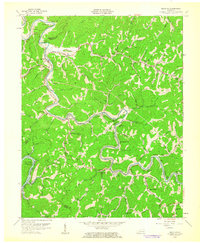
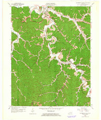
 1961 Jackson1963 Print · USGSBreathitt County's serpentine river valleys and coal-country hollows are captured here in the early sixties. Researchers can trace family roots through numerous remote burial sites like Blanche Haddix Cem and local landmarks like Lawson Sch.3 unique versions available
 - 1962 Map of Salyersville South, 1964 Print
 1962 Salyersville South1964 Print · USGSMagoffin County in the early sixties is a landscape defined by the winding Licking River and the reach of the coal-hauling rail lines. Researchers can trace family history through dozens of namesake landmarks like Howard-Shepard Cem, the settlement at Royalton, and the Carver Station stop.3 unique versions available
 - 1965 Map of Seitz, 1967 Print
 1965 Seitz1967 Print · USGSThe hill country of eastern Kentucky in the mid-sixties is shown here just as new parkways began to cut through the isolated hollows of Magoffin County. Genealogists and researchers can locate family landmarks such as the Cutuno Burton Cem, Wagers Sch, and the community of Seitz.2 unique versions available
End of results
Showing maps 1-13 of 13
Top cities of Breathitt County
Frequently asked questions
- What are the different types of historical maps available for Breathitt County?
- What is the oldest map of Breathitt County?
- Where can I purchase historical maps of Breathitt County for my home or office?
- Where can I download high-res historical maps of Breathitt County?
- Are there historical topographic maps available for Breathitt County?
- Is there historical aerial imagery available for Breathitt County?
- Where are historical maps of Breathitt County sourced from?